
Rami’s Guidebook
Sightseeing
Mount Nebo is an elevated ridge located in Jordan, approximately 710 metres above sea level. Part of the Abarim mountain range, Mount Nebo is mentioned in the Bible as the place where Moses was granted a view of the Promised Land before his death.
30 km from the apartment
28 명의 현지인이 추천하는 곳
네보산
Mount Nebo is an elevated ridge located in Jordan, approximately 710 metres above sea level. Part of the Abarim mountain range, Mount Nebo is mentioned in the Bible as the place where Moses was granted a view of the Promised Land before his death.
30 km from the apartment
Madaba is an ancient town in Jordan, southwest of the capital Amman. It’s known for its 6th-century mosaic map of the Holy Land in the Greek Orthodox Church of St. George. The Madaba Archaeological Park preserves the mosaic-rich Church of the Virgin Mary and artifacts from the Hellenistic, Roman, Byzantine and Islamic eras. Northwest, the biblical hill of Mount Nebo overlooks the Jordan Valley and the Dead Sea
27 km from the apartment.
21 명의 현지인이 추천하는 곳
Madaba
Madaba is an ancient town in Jordan, southwest of the capital Amman. It’s known for its 6th-century mosaic map of the Holy Land in the Greek Orthodox Church of St. George. The Madaba Archaeological Park preserves the mosaic-rich Church of the Virgin Mary and artifacts from the Hellenistic, Roman, Byzantine and Islamic eras. Northwest, the biblical hill of Mount Nebo overlooks the Jordan Valley and the Dead Sea
27 km from the apartment.
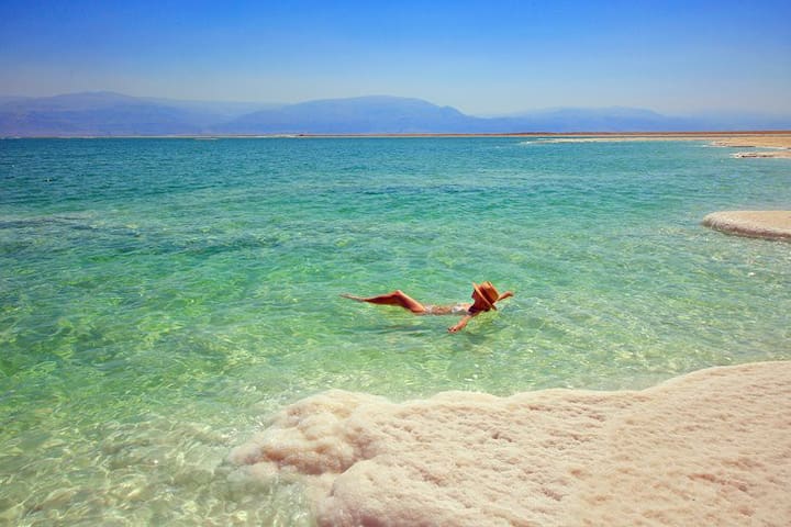
The Dead Sea is a salt lake. It lies in the Jordan Rift Valley, and its main tributary is the Jordan River. The lake's surface is 430.5 metres below sea level, making its shores the lowest land-based elevation on Earth.
Salt deposits
The Sedom Lagoon deposited evaporites mainly consisting of rock salt, which eventually reached a thickness of 2.3 km (1.43 mi) on the old basin floor in the area of today's Mount Sedom.[21]
Lake formation
Approximately two million years ago,[citation needed] the land between the Rift Valley and the Mediterranean Sea rose to such an extent that the ocean could no longer flood the area. Thus, the long lagoon became a landlocked lake.[20]
The first prehistoric lake to follow the Sedom Lagoon is named Lake Amora (which possibly appeared in the early Pleistocene; its sediments developed into the Amora (Samra) Formation, dated to over 200-80 kyr BP), followed by Lake Lisan (c. 70-14 kyr) and finally by the Dead Sea.[19]
Lake salinity
The water levels and salinity of the successive lakes (Amora, Lisan, Dead Sea) have either risen or fallen as an effect of the tectonic dropping of the valley bottom, and due to climate variation. As the climate became more arid, Lake Lisan finally shrank and became saltier, leaving the Dead Sea as its last remainder.[19][20]
From 70,000 to 12,000 years ago, Lake Lisan's level was 100 m (330 ft) to 250 m (820 ft) higher than its current level. Its level fluctuated dramatically, rising to its highest level around 26,000 years ago, indicating a very wet climate in the Near East.[22] Around 10,000 years ago, the lake's level dropped dramatically, probably even lower than today. During the last several thousand years, the lake has fluctuated approximately 400 m (1,300 ft), with some significant drops and rises. Current theories as to the cause of this dramatic drop in levels rule out volcanic activity; therefore, it may have been a seismic event.
Salt mounts formation
In prehistoric times[dubious – discuss], great amounts of sediment collected on the floor of Lake Amora. The sediment was heavier than the salt deposits and squeezed the salt deposits upwards into what are now the Lisan Peninsula and Mount Sodom (on the southwest side of the lake). Geologists explain the effect in terms of a bucket of mud into which a large flat stone is placed, forcing the mud to creep up the sides of the bucket. When the floor of the Dead Sea dropped further due to tectonic forces, the salt mounts of Lisan and Mount Sodom stayed in place as high cliffs (see salt dome).
Climate
The Dead Sea has a hot desert climate (Köppen climate classification BWh), with year-round sunny skies and dry air. It has less than 50 millimetres (2 in) mean annual rainfall and a summer average temperature between 32 and 39 °C (90 and 102 °F). Winter average temperatures range between 20 and 23 °C (68 and 73 °F). The region has weaker ultraviolet radiation, particularly the UVB (erythrogenic rays). Given the higher atmospheric pressure, the air has a slightly higher oxygen content (3.3% in summer to 4.8% in winter) as compared to oxygen concentration at sea level.[23][24] Barometric pressures at the Dead Sea were measured between 1061 and 1065 hPa and clinically compared with health effects at higher altitude.[25] (This barometric measure is about 5% higher than sea level standard atmospheric pressure of 1013.25 hPa, which is the global ocean mean or ATM.) The Dead Sea affects temperatures nearby because of the moderating effect a large body of water has on climate. During the winter, sea temperatures tend to be higher than land temperatures, and vice versa during the summer months. This is the result of the water's mass and specific heat capacity. On average, there are 192 days above 30 °C (86 °F) annually.[26]
40 km from the apartment
138 명의 현지인이 추천하는 곳
Dead Sea
The Dead Sea is a salt lake. It lies in the Jordan Rift Valley, and its main tributary is the Jordan River. The lake's surface is 430.5 metres below sea level, making its shores the lowest land-based elevation on Earth.
Salt deposits
The Sedom Lagoon deposited evaporites mainly consisting of rock salt, which eventually reached a thickness of 2.3 km (1.43 mi) on the old basin floor in the area of today's Mount Sedom.[21]
Lake formation
Approximately two million years ago,[citation needed] the land between the Rift Valley and the Mediterranean Sea rose to such an extent that the ocean could no longer flood the area. Thus, the long lagoon became a landlocked lake.[20]
The first prehistoric lake to follow the Sedom Lagoon is named Lake Amora (which possibly appeared in the early Pleistocene; its sediments developed into the Amora (Samra) Formation, dated to over 200-80 kyr BP), followed by Lake Lisan (c. 70-14 kyr) and finally by the Dead Sea.[19]
Lake salinity
The water levels and salinity of the successive lakes (Amora, Lisan, Dead Sea) have either risen or fallen as an effect of the tectonic dropping of the valley bottom, and due to climate variation. As the climate became more arid, Lake Lisan finally shrank and became saltier, leaving the Dead Sea as its last remainder.[19][20]
From 70,000 to 12,000 years ago, Lake Lisan's level was 100 m (330 ft) to 250 m (820 ft) higher than its current level. Its level fluctuated dramatically, rising to its highest level around 26,000 years ago, indicating a very wet climate in the Near East.[22] Around 10,000 years ago, the lake's level dropped dramatically, probably even lower than today. During the last several thousand years, the lake has fluctuated approximately 400 m (1,300 ft), with some significant drops and rises. Current theories as to the cause of this dramatic drop in levels rule out volcanic activity; therefore, it may have been a seismic event.
Salt mounts formation
In prehistoric times[dubious – discuss], great amounts of sediment collected on the floor of Lake Amora. The sediment was heavier than the salt deposits and squeezed the salt deposits upwards into what are now the Lisan Peninsula and Mount Sodom (on the southwest side of the lake). Geologists explain the effect in terms of a bucket of mud into which a large flat stone is placed, forcing the mud to creep up the sides of the bucket. When the floor of the Dead Sea dropped further due to tectonic forces, the salt mounts of Lisan and Mount Sodom stayed in place as high cliffs (see salt dome).
Climate
The Dead Sea has a hot desert climate (Köppen climate classification BWh), with year-round sunny skies and dry air. It has less than 50 millimetres (2 in) mean annual rainfall and a summer average temperature between 32 and 39 °C (90 and 102 °F). Winter average temperatures range between 20 and 23 °C (68 and 73 °F). The region has weaker ultraviolet radiation, particularly the UVB (erythrogenic rays). Given the higher atmospheric pressure, the air has a slightly higher oxygen content (3.3% in summer to 4.8% in winter) as compared to oxygen concentration at sea level.[23][24] Barometric pressures at the Dead Sea were measured between 1061 and 1065 hPa and clinically compared with health effects at higher altitude.[25] (This barometric measure is about 5% higher than sea level standard atmospheric pressure of 1013.25 hPa, which is the global ocean mean or ATM.) The Dead Sea affects temperatures nearby because of the moderating effect a large body of water has on climate. During the winter, sea temperatures tend to be higher than land temperatures, and vice versa during the summer months. This is the result of the water's mass and specific heat capacity. On average, there are 192 days above 30 °C (86 °F) annually.[26]
40 km from the apartment
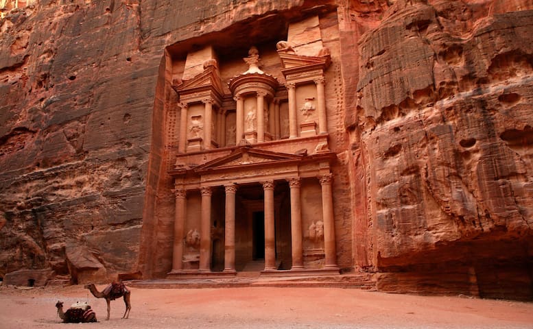
Petra is a famous archaeological site in Jordan's southwestern desert. Dating to around 300 B.C., it was the capital of the Nabatean Kingdom. Accessed via a narrow canyon called Al Siq, it contains tombs and temples carved into pink sandstone cliffs, earning its nickname, the "Rose City." Perhaps its most famous structure is 45m-high Al Khazneh, a temple with an ornate, Greek-style facade, and known as The Treasury.
225 km from the apartment
95 명의 현지인이 추천하는 곳
Wadi Musa
Petra is a famous archaeological site in Jordan's southwestern desert. Dating to around 300 B.C., it was the capital of the Nabatean Kingdom. Accessed via a narrow canyon called Al Siq, it contains tombs and temples carved into pink sandstone cliffs, earning its nickname, the "Rose City." Perhaps its most famous structure is 45m-high Al Khazneh, a temple with an ornate, Greek-style facade, and known as The Treasury.
225 km from the apartment
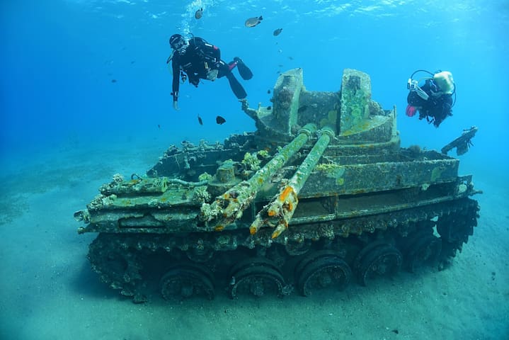
Aqaba is a Jordanian port city on the Red Sea's Gulf of Aqaba. Inhabited since 4000 B.C., it's home to the Islamic-era Aqaba Fort. Its beach resorts are popular for windsurfing and other water sports, and the area is a top destination for scuba divers, with notable dive sites including the Yamanieh coral reef in the Aqaba Marine Park, south of the city.
320 km from the apartmrnt
34 명의 현지인이 추천하는 곳
Aqaba
Aqaba is a Jordanian port city on the Red Sea's Gulf of Aqaba. Inhabited since 4000 B.C., it's home to the Islamic-era Aqaba Fort. Its beach resorts are popular for windsurfing and other water sports, and the area is a top destination for scuba divers, with notable dive sites including the Yamanieh coral reef in the Aqaba Marine Park, south of the city.
320 km from the apartmrnt
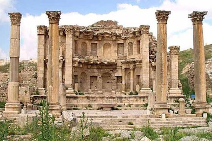
Jerash is a city in Jordan, north of the capital Amman. Inhabited since the Bronze Age, it’s known for the ruins of the walled Greco-Roman settlement of Gerasa just outside the modern city. These include the 2nd-century Hadrian’s Arch, the Corinthian columns of the Temple of Artemis and the huge Forum’s oval colonnade. The Jerash Archaeological Museum displays artifacts excavated from the site.
52 km from the apartment
35 명의 현지인이 추천하는 곳
Jerash
Jerash is a city in Jordan, north of the capital Amman. Inhabited since the Bronze Age, it’s known for the ruins of the walled Greco-Roman settlement of Gerasa just outside the modern city. These include the 2nd-century Hadrian’s Arch, the Corinthian columns of the Temple of Artemis and the huge Forum’s oval colonnade. The Jerash Archaeological Museum displays artifacts excavated from the site.
52 km from the apartment
Amman's Roman Theatre is a 6,000-seat, 2nd-century Roman theatre. A famous landmark in the Jordanian capital, it dates back to the Roman period when the city was known as Philadelphia.
15 km from the apartment
62 명의 현지인이 추천하는 곳
로마 극장
Taha Al HashemiAmman's Roman Theatre is a 6,000-seat, 2nd-century Roman theatre. A famous landmark in the Jordanian capital, it dates back to the Roman period when the city was known as Philadelphia.
15 km from the apartment
Al-Maghtas, officially known as Baptism Site "Bethany Beyond the Jordan", is an archaeological World Heritage site in Jordan, on the east bank of the Jordan River, considered to be the original location of the Baptism of Jesus by John the Baptist and venerated as such since at least the Byzantine period.
14 명의 현지인이 추천하는 곳
요르단 저편 베다니야
Al-Maghtas, officially known as Baptism Site "Bethany Beyond the Jordan", is an archaeological World Heritage site in Jordan, on the east bank of the Jordan River, considered to be the original location of the Baptism of Jesus by John the Baptist and venerated as such since at least the Byzantine period.
Wadi Rum is one of Jordan's most popular tourist sites and attracts a large number[quantify] of tourists from around the word. Wadi Rum is home to the Zalabieh tribe, who developed eco-adventure tourism and services throughout the protected area. They provide tours, guides, accommodation and facilities. They also run restaurants and small shops in the villages that provide meals and basic supplies for visitors. Their guide services include highly experienced mountain and trekking guides who have an unmatched knowledge of the local area and often speak fluently in two languages or more.[citation needed] Using local guides and services brings many benefits to the protected area. In particular, it enables people to continue earning a living from the land and helps to ensure that the protected area remains protected.
Popular activities in the desert environment include 4x4 tours, camel rides, camping under the stars, riding Arabian horses, hiking and rock-climbing among the massive rock formations. Travellers staying in the area can overnight in Bedouins style Camps located in the desert or glamping hotels. Hikers and adventurous travellers may also opt to camp outdoors under the stars. Tour operators offering this experience provide sleeping equipment, meals and transport.
21 명의 현지인이 추천하는 곳
와디 룸 보호구역
Wadi Rum is one of Jordan's most popular tourist sites and attracts a large number[quantify] of tourists from around the word. Wadi Rum is home to the Zalabieh tribe, who developed eco-adventure tourism and services throughout the protected area. They provide tours, guides, accommodation and facilities. They also run restaurants and small shops in the villages that provide meals and basic supplies for visitors. Their guide services include highly experienced mountain and trekking guides who have an unmatched knowledge of the local area and often speak fluently in two languages or more.[citation needed] Using local guides and services brings many benefits to the protected area. In particular, it enables people to continue earning a living from the land and helps to ensure that the protected area remains protected.
Popular activities in the desert environment include 4x4 tours, camel rides, camping under the stars, riding Arabian horses, hiking and rock-climbing among the massive rock formations. Travellers staying in the area can overnight in Bedouins style Camps located in the desert or glamping hotels. Hikers and adventurous travellers may also opt to camp outdoors under the stars. Tour operators offering this experience provide sleeping equipment, meals and transport.
It was rebuilt as a castle in 1184 by Izz al-Din Usama, a general in the army of Saladin. The castle controlled traffic along the road connecting Damascus and Egypt.[3] According to Saladin's historian Baha ad-Din ibn Shaddad, the fortress was primarily built in order to help the authorities in Damascus control the Bedouin tribes of the Jabal 'Auf. These enjoyed enough autonomy as to ally themselves to the Crusaders, and had at one point set up a 100-tent camp next to the Hospitaller castle of Belvoir on the opposite side of the Jordan Valley.[4] As such, Ajlun Castle is one of the very few Muslim fortresses built by the Ayyubids to protect their realm against Crusader incursions, which could come from Beisan or Belvoir in the west and from Karak in the south.
From its location, the fortress dominated a wide stretch of the northern Jordan Valley, controlled the three main passages that led to it (Wadi Kufranjah, Wadi Rajeb and Wadi al-Yabis), and protected the communication routes between southern Jordan and Syria. It was built to contain the progress of the Latin Kingdom, which with the |Lordship of Oultrejordain had gained a foothold in Transjordan, and as a retort to the castle of Belvoir a few miles south of the Sea of Galilee. Another major objective of the fortress was to protect the development and control of the iron mines of Ajlun.
12 명의 현지인이 추천하는 곳
아즐룬 성
It was rebuilt as a castle in 1184 by Izz al-Din Usama, a general in the army of Saladin. The castle controlled traffic along the road connecting Damascus and Egypt.[3] According to Saladin's historian Baha ad-Din ibn Shaddad, the fortress was primarily built in order to help the authorities in Damascus control the Bedouin tribes of the Jabal 'Auf. These enjoyed enough autonomy as to ally themselves to the Crusaders, and had at one point set up a 100-tent camp next to the Hospitaller castle of Belvoir on the opposite side of the Jordan Valley.[4] As such, Ajlun Castle is one of the very few Muslim fortresses built by the Ayyubids to protect their realm against Crusader incursions, which could come from Beisan or Belvoir in the west and from Karak in the south.
From its location, the fortress dominated a wide stretch of the northern Jordan Valley, controlled the three main passages that led to it (Wadi Kufranjah, Wadi Rajeb and Wadi al-Yabis), and protected the communication routes between southern Jordan and Syria. It was built to contain the progress of the Latin Kingdom, which with the |Lordship of Oultrejordain had gained a foothold in Transjordan, and as a retort to the castle of Belvoir a few miles south of the Sea of Galilee. Another major objective of the fortress was to protect the development and control of the iron mines of Ajlun.
Umm Qais or Qays is a town in northern Jordan principally known for its proximity to the ruins of the ancient Gadara. It is the largest city in the Bani Kinanah Department and Irbid Governorate in the extreme northwest of the country, near Jordan's borders with Palestine and Syria.
Gadara was a centre of Greek culture in the region during the Hellenistic and Roman periods.[2]
The oldest archaeological evidence at Umm Qais, extends back to the second half of the third century BC.[3] and the site appears to have been founded as a military colony by Alexander the Great's Macedonian Greeks. However, the site's name "Gadara" is not Greek in origin, but rather a Greek version of a local Semitic name meaning "fortifications" or "the fortified city" suggesting the military colony was founded on a pre-existing fortified site.[4]
Located on the boundary between Seleucid and Ptolemaic territory, the city was strategically important and was repeatedly the focus of military conquests throughout the succession of Syrian Wars between 274 - 188 BCE. The city's military importance during this period was noted by the Greek historian Polybius' describing it in 218 BCE as a fortress and "the strongest of all places in the region".
The Roman-Seleucid War (192 - 188BCE) weakened Seleucid control over the region devolving autonomy in Palestine and trans-Jordan to the Hasmonean, Iturean and Nabatean kingdoms whose rivalries continued to make Gadara a strategically important city and the focus of continued conflict.
In 98 BCE the Hasmonean King Alexander Jannaeus subjected the city to a 10 month siege, wresting control of the city and the trade routes to the ports of the Eastern Mediterranean that passed through it from the Nabateans.[5][6] The Nabatean response culminated in Nabatean King Obdas 1st' decisive victory over Jannaeus at the Battle of Gadara in 93 BCE.
In 63 BCE, Roman general Pompey conquered the region, Gadara was rebuilt and became a member of the semi-autonomous Roman Decapolis.[7][8] 33 years later Augustus attached it to the Jewish kingdom of his ally, Herod. After King Herod's death in 4 BCE, Gadara became part of the Roman province of Syria.[9]
To supply larger populations Gadara, and the neighbouring Decapolis cities of Adraa (Dera'a, Syria) and Abila (Qweilbeh, Jordan) undertook construction of a water supply system of 170 km of aqueduct tunnels connecting the cities to springs throughout southern Syria and an artificially constructed lake at Dille. Constructed between 90 - 210 CE the network of rock cut tunnels included 2,900 access shafts, and a single 106km section represents one of the most significant hydro-engineering accomplishments of the ancient world. During the Severan period (193 – 235CE) the city underwent a rapid expansion westwards and many of the large civic monuments still visible on the site today date to this period and attest to an increase in importance and prosperity. After the Christianisation of the Eastern Roman Empire, Gadara retained its important regional status and became for many years the seat of a Christian bishop.[10]
Early Islamic periodEdit
The Battle of Yarmouk in 636 CE a short distance from Gadara, brought the entire region under Arab-Muslim rule.
On 18th January 749 CE much of the city was destroyed by the Galilee earthquake. Whilst the city was extensively damaged, archaeological evidence of limited reconstruction, including conversion of the large five aisle basilica church into a mosque indicates the continued settlement of the site at least into the 11th Century.
By the 13th Century the site is noted in historic sources under the new name of "Mukais" a local term meaning border place or customs house and from which the modern name of Umm Qais gradual derived.
Ottoman period
In 1596 it appeared in the Ottoman tax registers named as Mkeis, situated in the nahiya (subdistrict) of Bani Kinana, part of the Sanjak of Hawran. It had 21 households and 15 bachelors; all Muslim, in addition to 3 Christian households. The villagers paid a fixed tax-rate of 25% on agricultural products; including wheat, barley, summer crops, fruit trees, goats and bee-hives. The total tax was 8,500 akçe.[11]
In 1806 Ulrich Jasper Seetzen visited Umm Qais and identified it as the location of ancient Gadara, describing the Ottoman settlement and the tombs and other monuments still visible on the surface. The ancient ruins at Um Keis were recorded again by western visitors in 1816 and 1838.[12] By 1899 Schumacher, visiting the site as part of his survey work for the Hijaz railway records the village had expanded significantly with the construction of larger houses, noting also that many of the tombs recorded by early visitors were no longer present. Umm Qais's most impressive building, the Ottoman governor's residence known as Beit Rousan, "Rousan House", dates to this period of expansion in the Late Ottoman period.
Modern periodEdit
In 1920 the Madafa and Hosh (courtyard) of Hajj Mahmoud al Rousan's house in Umm Qais hosted a conference of Arab leaders from across the middle east to draw up a treaty in response to the British and French plan to divide the region following the end of the British and French Mandates.
The village's school was opened in 1922 by HRH King Abdullah I of Jordan making it the third oldest school in Jordan after those in Salt and Kerak.
By 1961 the population of Umm Qais was 1,196 inhabitants.[13]
During the 1967 Arab-Israeli war Umm Qais' strategic location put it on the front line of conflict again. Heavy shelling from the Golan Heights and aircraft bombing damaged both the village and ancient city. The underground Roman mausoleum below the five aisled basilica in the west of the ancient was discovered by accident by the Jordanian army and the large intact underground chamber was used as a temporary field hospital during the conflict.
움 카이스 고고학 유적지
Ash Shounah Ash ShemaleyahUmm Qais or Qays is a town in northern Jordan principally known for its proximity to the ruins of the ancient Gadara. It is the largest city in the Bani Kinanah Department and Irbid Governorate in the extreme northwest of the country, near Jordan's borders with Palestine and Syria.
Gadara was a centre of Greek culture in the region during the Hellenistic and Roman periods.[2]
The oldest archaeological evidence at Umm Qais, extends back to the second half of the third century BC.[3] and the site appears to have been founded as a military colony by Alexander the Great's Macedonian Greeks. However, the site's name "Gadara" is not Greek in origin, but rather a Greek version of a local Semitic name meaning "fortifications" or "the fortified city" suggesting the military colony was founded on a pre-existing fortified site.[4]
Located on the boundary between Seleucid and Ptolemaic territory, the city was strategically important and was repeatedly the focus of military conquests throughout the succession of Syrian Wars between 274 - 188 BCE. The city's military importance during this period was noted by the Greek historian Polybius' describing it in 218 BCE as a fortress and "the strongest of all places in the region".
The Roman-Seleucid War (192 - 188BCE) weakened Seleucid control over the region devolving autonomy in Palestine and trans-Jordan to the Hasmonean, Iturean and Nabatean kingdoms whose rivalries continued to make Gadara a strategically important city and the focus of continued conflict.
In 98 BCE the Hasmonean King Alexander Jannaeus subjected the city to a 10 month siege, wresting control of the city and the trade routes to the ports of the Eastern Mediterranean that passed through it from the Nabateans.[5][6] The Nabatean response culminated in Nabatean King Obdas 1st' decisive victory over Jannaeus at the Battle of Gadara in 93 BCE.
In 63 BCE, Roman general Pompey conquered the region, Gadara was rebuilt and became a member of the semi-autonomous Roman Decapolis.[7][8] 33 years later Augustus attached it to the Jewish kingdom of his ally, Herod. After King Herod's death in 4 BCE, Gadara became part of the Roman province of Syria.[9]
To supply larger populations Gadara, and the neighbouring Decapolis cities of Adraa (Dera'a, Syria) and Abila (Qweilbeh, Jordan) undertook construction of a water supply system of 170 km of aqueduct tunnels connecting the cities to springs throughout southern Syria and an artificially constructed lake at Dille. Constructed between 90 - 210 CE the network of rock cut tunnels included 2,900 access shafts, and a single 106km section represents one of the most significant hydro-engineering accomplishments of the ancient world. During the Severan period (193 – 235CE) the city underwent a rapid expansion westwards and many of the large civic monuments still visible on the site today date to this period and attest to an increase in importance and prosperity. After the Christianisation of the Eastern Roman Empire, Gadara retained its important regional status and became for many years the seat of a Christian bishop.[10]
Early Islamic periodEdit
The Battle of Yarmouk in 636 CE a short distance from Gadara, brought the entire region under Arab-Muslim rule.
On 18th January 749 CE much of the city was destroyed by the Galilee earthquake. Whilst the city was extensively damaged, archaeological evidence of limited reconstruction, including conversion of the large five aisle basilica church into a mosque indicates the continued settlement of the site at least into the 11th Century.
By the 13th Century the site is noted in historic sources under the new name of "Mukais" a local term meaning border place or customs house and from which the modern name of Umm Qais gradual derived.
Ottoman period
In 1596 it appeared in the Ottoman tax registers named as Mkeis, situated in the nahiya (subdistrict) of Bani Kinana, part of the Sanjak of Hawran. It had 21 households and 15 bachelors; all Muslim, in addition to 3 Christian households. The villagers paid a fixed tax-rate of 25% on agricultural products; including wheat, barley, summer crops, fruit trees, goats and bee-hives. The total tax was 8,500 akçe.[11]
In 1806 Ulrich Jasper Seetzen visited Umm Qais and identified it as the location of ancient Gadara, describing the Ottoman settlement and the tombs and other monuments still visible on the surface. The ancient ruins at Um Keis were recorded again by western visitors in 1816 and 1838.[12] By 1899 Schumacher, visiting the site as part of his survey work for the Hijaz railway records the village had expanded significantly with the construction of larger houses, noting also that many of the tombs recorded by early visitors were no longer present. Umm Qais's most impressive building, the Ottoman governor's residence known as Beit Rousan, "Rousan House", dates to this period of expansion in the Late Ottoman period.
Modern periodEdit
In 1920 the Madafa and Hosh (courtyard) of Hajj Mahmoud al Rousan's house in Umm Qais hosted a conference of Arab leaders from across the middle east to draw up a treaty in response to the British and French plan to divide the region following the end of the British and French Mandates.
The village's school was opened in 1922 by HRH King Abdullah I of Jordan making it the third oldest school in Jordan after those in Salt and Kerak.
By 1961 the population of Umm Qais was 1,196 inhabitants.[13]
During the 1967 Arab-Israeli war Umm Qais' strategic location put it on the front line of conflict again. Heavy shelling from the Golan Heights and aircraft bombing damaged both the village and ancient city. The underground Roman mausoleum below the five aisled basilica in the west of the ancient was discovered by accident by the Jordanian army and the large intact underground chamber was used as a temporary field hospital during the conflict.
The Amman Citadel is an archeological site at the center of downtown Amman, the capital of Jordan. The L-shaped hill is one of the seven hills that originally made up Amman. The Citadel has a long history of occupation by many great civilizations
58 명의 현지인이 추천하는 곳
암만 시타델
146 K. Ali Ben Al-Hussein St.The Amman Citadel is an archeological site at the center of downtown Amman, the capital of Jordan. The L-shaped hill is one of the seven hills that originally made up Amman. The Citadel has a long history of occupation by many great civilizations
The Boulevard is a mixed-use complex, centrally located within the heart of Abdali. It features a long pedestrian promenade, bordered by 12 buildings housing retail outlets, food & beverage concepts, modern office spaces, exclusive rooftop lounges, as well as luxurious hotel serviced apartments, managed and operated by Arjaan Rotana.
16 명의 현지인이 추천하는 곳
부르바드
Jamal Al JuqahThe Boulevard is a mixed-use complex, centrally located within the heart of Abdali. It features a long pedestrian promenade, bordered by 12 buildings housing retail outlets, food & beverage concepts, modern office spaces, exclusive rooftop lounges, as well as luxurious hotel serviced apartments, managed and operated by Arjaan Rotana.
The Ma'in Hot Springs also known as Hammamat Ma'in are a series of hot mineral springs and waterfalls located between Madaba and the Dead Sea in Madaba Governorate, Jordan
14 명의 현지인이 추천하는 곳
Ma'in Hot Springs
The Ma'in Hot Springs also known as Hammamat Ma'in are a series of hot mineral springs and waterfalls located between Madaba and the Dead Sea in Madaba Governorate, Jordan
Dana Biosphere Reserve
헤라클레스 신전
132 Museum St로마 님페움 암만
Al Hashemi모세 기념 교회
Al Quds Street아부 다르위시 모스크
Abu DarwishSt. John the Baptist Roman Catholic Church
Princess Haya Street칠수면자 동굴 (아샤불 카프)
Ahl Al Kahf死海 박물관
킹 후세인 모스크
Al-Sha'b Street왕 압둘라 1 성전
로마 극장
Taha Al Hashemi움 카이스 고고학 유적지
Ash Shounah Ash ShemaleyahAjloun Castle Visitors Car Park
Ajloun cable car station 2
Al-Karak Castle Ticket Office
Azraq Wetlands Reserve
Wadi al Mujib, 요르단
무지브 자연보호구역
Salt Beach dead sea
Ayla Oasis
요르단 저편 베다니야
As-Salt Archaeological Museum
알 웨이브데
Rainbow Street
Diving Center Aqaba
Jordan diving centre
앰달리 프로젝트
King Talal Dam Viewing Area
Adventure PROS ادفنشر بروز
Abdoun Bridge
74 Muhammad Ali BedeirThe Ritz-Carlton, Amman
르 로얄 암만
Museums
라 스토리아 관광 복합 시설
요르단 박물관
Ali bin Abi Taleb StreetJordan Archaeological Museum
로이스 에이스보리 민주 모자
At TibbiyyaJordanian Museum of Popular Traditions
Jordan National Gallery of Fine Arts
요르단 어린이 박물관
C208 King Abdallah Ben Al Hussein Ath Thani왕립 탱크 박물관
88 As Sakhrah Al MusharrafahEdifice of The Martyrs Museum
شارع صرح الشهيد로마 극장
Taha Al HashemiAmman Panorama Art Gallery
Al HashemiOld Signs of Amman متحف آرمات عمان
라 스토리아 관광 복합 시설
As-Salt Archaeological Museum
Food scene
Zambak Turkish Cuisine
An amazing Turkish restaurant, just 1 minute from the apartment.
Very affordable resturant specializes in traditional food like Hummus, Foul and Falafel.
Location : Old city center.
46 명의 현지인이 추천하는 곳
Hashem Restaurant Down Town
Very affordable resturant specializes in traditional food like Hummus, Foul and Falafel.
Location : Old city center.
Jordanian restaurant specializes in traditional food like Hummus, Foul and Falafel. Madina Munawara St 189, Amman, Jordan.
Location : Madina mnwarah street.
16 명의 현지인이 추천하는 곳
Abu Jbara
189 Al-Madina Al-Monawara StJordanian restaurant specializes in traditional food like Hummus, Foul and Falafel. Madina Munawara St 189, Amman, Jordan.
Location : Madina mnwarah street.
You must try the tradional Jordanian cuisine ( Mansaf).
Location : 1- Old city center
2-Madina mnwara street (Alwaha circle).
3- 7th circle.
10 명의 현지인이 추천하는 곳
Al Quds Restaurant
8 King Al Hussein StYou must try the tradional Jordanian cuisine ( Mansaf).
Location : 1- Old city center
2-Madina mnwara street (Alwaha circle).
3- 7th circle.
Shams El Balad
69 Mu'Ath Bin Jabal StreetBikers Village ®️Amman
Queen Alia Airport RoadCafes and resturants.
3 km from the appt.
Hamada Restaurant
Abu Jbara
189 Al-Madina Al-Monawara StMeat and Cheese Burger - Mecca st
Firefly Burger Jabal Amman
AlMousali
WINGERS
Ahmad abu akazمطعم شربها للمناسف (sharebha restaurant for Mansaf)
Da7berha restaurant
Habibah Sweets
Brisket Amman
Abdallah Ben MassoudMEAT ME BBQ & SMOKE HOUSE
Shi Shawerma شي شاورما
Wahib Al AfyouniShawerma Reem
Lebanese Um Khalil - Jabal Amman
Buffalo Wings & Rings - 7th Circle
Al MawaddahMr. Burritos (Mecca St. Branch)
Mr. Kumpir
Cube Burger
Crispy Chicken -7th circle - كرسبي تشكن- الدوار السابع
Fame Restaurant
Abdul Rahman AalawiSufra Restaurant
26 Al Rainbow Stshopping
압달리 몰
Suliman Al Nabulsi Street14 km from the apartment
City Mall
13 km from the apartment
Taj Cinemas
72 Pr. Hashim St9 km from the apartment
Safeway
Princess Taghreed Mohammad StreetGrocery market.
2 km from the appartment
911 Supermarket
3 Al Arz St300 M from the appartment
Public Park
암만 국립공원
15Al Hussein Public Parks
A208 King Abdallah Ben Al Hussein Ath Thanicafe
The Duke's Diwan
شارع الملك فيصلRumi Cafe
14 Ash Shariaah CollegeSwefieh Village
Resturants & Cafes
Dimitri's Coffee - Makka Street
Mamdouh As SarirahEspressolab
Trasimeno Coffee House
Marouf Cafe
Al Ameed Coffee Sweifieh - بن العميد الصويفية