
Matteo’s guidebook
My favourite beaches - Le mie spiagge preferite
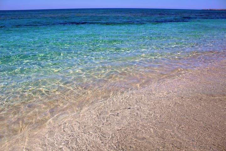
A real pearl of Sardinia and the whole of the Mediterranean, an unspoilt jewel on the central-western coast of the Island: three kilometres of sand dunes, turquoise and emerald green sea and lush vegetation all around.
It is not easy to get to, which makes it even more enchanting, and is located in a setting in which nature is almost completely unspoilt, with no villages nearby. In Scivu, you will witness a deafening silence, interrupted only by the surf of the sea and the cries of the seagulls.
The water is astonishingly transparent and its colour is dazzling when it is lit by the sun's reflections. The most seductive moment is sunset, when the sand and the rock faces turn red. The seabed is varied: gullies, sandbanks and a scattering of rocks - everything that snorkelling enthusiasts are looking for.
Perla incontaminata del Mediterraneo nella costa sud-occidentale della Sardegna: dune di sabbia, mare turchese e smeraldo, attorno lussureggiante vegetazione.
Non è facile da raggiungere, il che la rende ancora più incantevole, e si trova in un ambiente in cui la natura è quasi completamente incontaminata, senza villaggi nelle vicinanze. A Scivu, assisterete a un silenzio assordante, interrotto solo dalla spuma del mare e dalle grida dei gabbiani.
L'acqua è sorprendentemente trasparente e il suo colore è abbagliante quando è illuminato dai riflessi del sole. Il momento più seducente è il tramonto, quando la sabbia e le pareti rocciose diventano rosse. Il fondale marino è vario: calanchi, banchi di sabbia e una serie di scogli: tutto ciò che gli appassionati di snorkeling stanno cercando.
27 명의 현지인이 추천하는 곳
사이부 비치 (Scivu Beach)
A real pearl of Sardinia and the whole of the Mediterranean, an unspoilt jewel on the central-western coast of the Island: three kilometres of sand dunes, turquoise and emerald green sea and lush vegetation all around.
It is not easy to get to, which makes it even more enchanting, and is located in a setting in which nature is almost completely unspoilt, with no villages nearby. In Scivu, you will witness a deafening silence, interrupted only by the surf of the sea and the cries of the seagulls.
The water is astonishingly transparent and its colour is dazzling when it is lit by the sun's reflections. The most seductive moment is sunset, when the sand and the rock faces turn red. The seabed is varied: gullies, sandbanks and a scattering of rocks - everything that snorkelling enthusiasts are looking for.
Perla incontaminata del Mediterraneo nella costa sud-occidentale della Sardegna: dune di sabbia, mare turchese e smeraldo, attorno lussureggiante vegetazione.
Non è facile da raggiungere, il che la rende ancora più incantevole, e si trova in un ambiente in cui la natura è quasi completamente incontaminata, senza villaggi nelle vicinanze. A Scivu, assisterete a un silenzio assordante, interrotto solo dalla spuma del mare e dalle grida dei gabbiani.
L'acqua è sorprendentemente trasparente e il suo colore è abbagliante quando è illuminato dai riflessi del sole. Il momento più seducente è il tramonto, quando la sabbia e le pareti rocciose diventano rosse. Il fondale marino è vario: calanchi, banchi di sabbia e una serie di scogli: tutto ciò che gli appassionati di snorkeling stanno cercando.
A desert bathed by emerald sea and swept by the wind that moulds it and turns it into an ideal destination for surfers. Torre dei Corsari is one of the pearls of the Green Coast, in the Arbus territory, and it is named after the Spanish tower called Flumentorgiu (17th century), a watchtower against attacks by Saracen pirates. From the promontory, you can admire, to the south, a bay with calcareous cliffs, while to the north you can see the immense Is Arenas ‘e s’Acqua e s’Ollastru beach, all the way to the delicious secluded coves and steep rocks, a paradise for fishing aficionados.
The beach is one and a half kilometre long: golden dunes of astonishing beauty, they look like hills, clumped and shifted by the endless action of the Mistral. The colour of the sand, which is covered by sea lilies, wallflowers and sand poppies in spring, contrasts and highlights the landscape behind, made of hills covered by Mediterranean scrubs, with giant strawberry trees, junipers, brooms and mastics. From every angle and at any given time, Torre dei Corsari offers you unforgettable views, and, in the evening, marvellous sunsets. The beach is accessible to disabled people, has a parking area (for campers as well), and it is possible to rent umbrellas and beach chairs. There are also plenty hotels, cafés and restaurants.
Un deserto lambito dal mare smeraldo e spazzato dal vento che lo modella e ne fa una delle mete preferite dai surfisti. Torre dei Corsari è una delle perle della Costa Verde, nel territorio di Arbus, il cui nome deriva dalla torre spagnola di Flumentorgiu (XVII sec.), vedetta contro le incursioni dei pirati saraceni. Dal promontorio ammirerai a sud una baia con falesie calcaree, mentre a nord il tuo sguardo spazierà dall’immensa spiaggia di Is Arenas ‘e s’Acqua e s’Ollastru fino alle deliziose calette riparate e a rocce impervie, paradiso degli amanti della pesca.
La spiaggia è lunga un chilometro e mezzo: dune dorate dalla bellezza strabiliante, sembrano colline ammassate e mosse dall’incessante azione del maestrale. Il colore della sabbia, coperta in primavera da gigli di mare, violacciocca e papavero della sabbia, contrasta ed esalta il paesaggio retrostante, fatto di colline ricoperte da un tappeto di macchia mediterranea, con corbezzoli, ginepri, ginestre e lentischi. Da ogni angolo e in qualsiasi momento, Torre dei Corsari regala indimenticabili panorami e, alla sera, meravigliosi tramonti. La spiaggia è accessibile a diversamente abili, dotata di parcheggio, adatto anche ai camper, e potrai noleggiarvi ombrelloni, sdraio e patino. Non mancano hotel e strutture ricettive, bar e ristoranti.
17 명의 현지인이 추천하는 곳
Torre dei Corsari
A desert bathed by emerald sea and swept by the wind that moulds it and turns it into an ideal destination for surfers. Torre dei Corsari is one of the pearls of the Green Coast, in the Arbus territory, and it is named after the Spanish tower called Flumentorgiu (17th century), a watchtower against attacks by Saracen pirates. From the promontory, you can admire, to the south, a bay with calcareous cliffs, while to the north you can see the immense Is Arenas ‘e s’Acqua e s’Ollastru beach, all the way to the delicious secluded coves and steep rocks, a paradise for fishing aficionados.
The beach is one and a half kilometre long: golden dunes of astonishing beauty, they look like hills, clumped and shifted by the endless action of the Mistral. The colour of the sand, which is covered by sea lilies, wallflowers and sand poppies in spring, contrasts and highlights the landscape behind, made of hills covered by Mediterranean scrubs, with giant strawberry trees, junipers, brooms and mastics. From every angle and at any given time, Torre dei Corsari offers you unforgettable views, and, in the evening, marvellous sunsets. The beach is accessible to disabled people, has a parking area (for campers as well), and it is possible to rent umbrellas and beach chairs. There are also plenty hotels, cafés and restaurants.
Un deserto lambito dal mare smeraldo e spazzato dal vento che lo modella e ne fa una delle mete preferite dai surfisti. Torre dei Corsari è una delle perle della Costa Verde, nel territorio di Arbus, il cui nome deriva dalla torre spagnola di Flumentorgiu (XVII sec.), vedetta contro le incursioni dei pirati saraceni. Dal promontorio ammirerai a sud una baia con falesie calcaree, mentre a nord il tuo sguardo spazierà dall’immensa spiaggia di Is Arenas ‘e s’Acqua e s’Ollastru fino alle deliziose calette riparate e a rocce impervie, paradiso degli amanti della pesca.
La spiaggia è lunga un chilometro e mezzo: dune dorate dalla bellezza strabiliante, sembrano colline ammassate e mosse dall’incessante azione del maestrale. Il colore della sabbia, coperta in primavera da gigli di mare, violacciocca e papavero della sabbia, contrasta ed esalta il paesaggio retrostante, fatto di colline ricoperte da un tappeto di macchia mediterranea, con corbezzoli, ginepri, ginestre e lentischi. Da ogni angolo e in qualsiasi momento, Torre dei Corsari regala indimenticabili panorami e, alla sera, meravigliosi tramonti. La spiaggia è accessibile a diversamente abili, dotata di parcheggio, adatto anche ai camper, e potrai noleggiarvi ombrelloni, sdraio e patino. Non mancano hotel e strutture ricettive, bar e ristoranti.
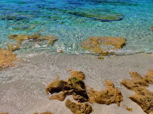
The beach of Portu Maga, found halfway along the magnificent Costa Verde, has averagely coarse, light-coloured sand along with a few surfacing rocks.
Its waters are of a changing blue due to the plays of light created by the sun reflecting off the sea bed. A further splash of colour is provided by the chromatic mix of the golden sand, the rocks, the brilliant blue of the sea and the carpet of typical Mediterranean brush vegetation that cloaks the hills to the rear.
La spiaggia di Portu Maga, in posizione centrale nella magnifica Costa verde, si presenta con un fondo di sabbia chiara a grani medi con alcuni scogli affioranti. Le sue acque sono di un azzurro cangiante per i giochi di luce creati dal sole riflesso sul fondale. Un effetto cromatico suggestivo è offerto dalla mescolanza del dorato della sabbia, del colore delle rocce, dell'azzurro intenso del mare e dal tappeto di vegetazione tipica della macchia mediterranea che ricopre le colline alle sue spalle.
Portu Maga
The beach of Portu Maga, found halfway along the magnificent Costa Verde, has averagely coarse, light-coloured sand along with a few surfacing rocks.
Its waters are of a changing blue due to the plays of light created by the sun reflecting off the sea bed. A further splash of colour is provided by the chromatic mix of the golden sand, the rocks, the brilliant blue of the sea and the carpet of typical Mediterranean brush vegetation that cloaks the hills to the rear.
La spiaggia di Portu Maga, in posizione centrale nella magnifica Costa verde, si presenta con un fondo di sabbia chiara a grani medi con alcuni scogli affioranti. Le sue acque sono di un azzurro cangiante per i giochi di luce creati dal sole riflesso sul fondale. Un effetto cromatico suggestivo è offerto dalla mescolanza del dorato della sabbia, del colore delle rocce, dell'azzurro intenso del mare e dal tappeto di vegetazione tipica della macchia mediterranea che ricopre le colline alle sue spalle.
It appears to the right of the modern little tourist harbour, with light reflecting on the sand and splendid blue waters. The beach of Buggerru is a soft and welcoming expanse washed by a transparent sea of iridescent colours, which often receives awards from Legambiente (Italian environmentalist association) and the Touring Club. The waters are shallow and the seabed is sandy.
The beach is very close to the residential area, so all the main services are at your disposal.
Spunta alla destra del moderno porticciolo turistico, coi riflessi chiari della sabbia e con splendide tonalità azzurre delle sue acque. La spiaggia di Buggerru è una distesa morbida e calda che si immerge in un mare dai colori cangianti e limpidissimo (premiato da Legambiente e Touring Club). Il fondale basso e sabbioso. La spiaggia è a due passi dal centro abitato, perciò sono a portata di mano tutti i principali servizi.
30 명의 현지인이 추천하는 곳
Buggerru
It appears to the right of the modern little tourist harbour, with light reflecting on the sand and splendid blue waters. The beach of Buggerru is a soft and welcoming expanse washed by a transparent sea of iridescent colours, which often receives awards from Legambiente (Italian environmentalist association) and the Touring Club. The waters are shallow and the seabed is sandy.
The beach is very close to the residential area, so all the main services are at your disposal.
Spunta alla destra del moderno porticciolo turistico, coi riflessi chiari della sabbia e con splendide tonalità azzurre delle sue acque. La spiaggia di Buggerru è una distesa morbida e calda che si immerge in un mare dai colori cangianti e limpidissimo (premiato da Legambiente e Touring Club). Il fondale basso e sabbioso. La spiaggia è a due passi dal centro abitato, perciò sono a portata di mano tutti i principali servizi.
In the Gulf of Oristano, in the centre of Sardinia’s western coast, embraced by two rocky cliffs, there is a half-moon made up of coloured quartz fragments: it is considered the pearl of the Sinis peninsula.
Various hundreds of metres of turquoise sea and grains of ultra-thin quartz, similar to grains of rice, in a beautiful palette of colours ranging from green to white and delicate pink.
Do not forget to carry a camera and a snorkelling mask with you: the sea bottom is deep right from its first metres, and takes on an intense green and azure colour that gradually turns into blue. The clear waters allow for a sharp view of the marine species that inhabit the area. You will see schools of confident little fish that will shyly swim near the posidonia formations, and discover submerged natural treasures. In some of the small bays of the long beach, you can admire segments of coast with sand made up of ultra-white rice grains and crystal-clear pure water.
Nel golfo di Oristano, al centro della costa occidentale della Sardegna, abbracciata da due scogliere rocciose, c’è una ‘mezzaluna’ di chicchi di quarzo colorati: è considerata la perla della penisola del Sinis.
Varie centinaia di metri di mare turchese e granelli tondeggianti di quarzo finissimo, simile a chicchi di riso, declinato in una suggestiva escalation di colori, dal verde al bianco, passando per il delicatissimo rosa.
Porta con te macchina fotografica e maschera subacquea: il fondale, profondo fin dai primi metri, assume un colore verde intenso e azzurro che si trasforma in blu. La limpidezza delle acque ti permetterà una chiara visuale sulla vita delle specie marine che le popolano. Vedrai banchi di piccoli pesci confidenti che timidamente ti si avvicinano dalle formazioni di posidonia e andrai alla scoperta di tesori naturali sommersi. In alcune calette della lunga spiaggia, invece, potrai ammirare tratti di costa con sabbia formata da bianchissimi chicchi di riso e un acqua pulitissima e cristallina.
Is Arutas
Is ArutasIn the Gulf of Oristano, in the centre of Sardinia’s western coast, embraced by two rocky cliffs, there is a half-moon made up of coloured quartz fragments: it is considered the pearl of the Sinis peninsula.
Various hundreds of metres of turquoise sea and grains of ultra-thin quartz, similar to grains of rice, in a beautiful palette of colours ranging from green to white and delicate pink.
Do not forget to carry a camera and a snorkelling mask with you: the sea bottom is deep right from its first metres, and takes on an intense green and azure colour that gradually turns into blue. The clear waters allow for a sharp view of the marine species that inhabit the area. You will see schools of confident little fish that will shyly swim near the posidonia formations, and discover submerged natural treasures. In some of the small bays of the long beach, you can admire segments of coast with sand made up of ultra-white rice grains and crystal-clear pure water.
Nel golfo di Oristano, al centro della costa occidentale della Sardegna, abbracciata da due scogliere rocciose, c’è una ‘mezzaluna’ di chicchi di quarzo colorati: è considerata la perla della penisola del Sinis.
Varie centinaia di metri di mare turchese e granelli tondeggianti di quarzo finissimo, simile a chicchi di riso, declinato in una suggestiva escalation di colori, dal verde al bianco, passando per il delicatissimo rosa.
Porta con te macchina fotografica e maschera subacquea: il fondale, profondo fin dai primi metri, assume un colore verde intenso e azzurro che si trasforma in blu. La limpidezza delle acque ti permetterà una chiara visuale sulla vita delle specie marine che le popolano. Vedrai banchi di piccoli pesci confidenti che timidamente ti si avvicinano dalle formazioni di posidonia e andrai alla scoperta di tesori naturali sommersi. In alcune calette della lunga spiaggia, invece, potrai ammirare tratti di costa con sabbia formata da bianchissimi chicchi di riso e un acqua pulitissima e cristallina.
The northwesterly mistral wind caresses the sand that resembles grains of rice. The fine, golden sand, made of tiny pink and white pebbles of quartz, colours Mari Ermi with multiple iridescent shades.
Mari Ermi is protected from behind by a large 20-hectare pond. Numerous species of marine birds live in the body of water, including the greater flamingo. You will notice them with their heads immersed in the water, intent on eating the shrimps that give them their distinctive pink colour.
Il maestrale accarezza i suoi granelli simili a chicchi di riso. La sabbia dorata, fine e con piccolissimi ciottoli di quarzo bianco e rosa colorano Mari Ermi di molteplici sfumature cangianti.
Mari Ermi è protetta alle spalle da uno stagno esteso venti ettari. Nello specchio d’acqua vivono numerose specie di uccelli marini, tra cui il fenicottero rosa. Lo noterai con la testa immersa nell’acqua intento a mangiare i gamberetti che gli conferiscono il caratteristico colorito.
32 명의 현지인이 추천하는 곳
Mari Ermi
The northwesterly mistral wind caresses the sand that resembles grains of rice. The fine, golden sand, made of tiny pink and white pebbles of quartz, colours Mari Ermi with multiple iridescent shades.
Mari Ermi is protected from behind by a large 20-hectare pond. Numerous species of marine birds live in the body of water, including the greater flamingo. You will notice them with their heads immersed in the water, intent on eating the shrimps that give them their distinctive pink colour.
Il maestrale accarezza i suoi granelli simili a chicchi di riso. La sabbia dorata, fine e con piccolissimi ciottoli di quarzo bianco e rosa colorano Mari Ermi di molteplici sfumature cangianti.
Mari Ermi è protetta alle spalle da uno stagno esteso venti ettari. Nello specchio d’acqua vivono numerose specie di uccelli marini, tra cui il fenicottero rosa. Lo noterai con la testa immersa nell’acqua intento a mangiare i gamberetti che gli conferiscono il caratteristico colorito.
Piscinas is considered the Pearl of the Costa Verde, is a dazzling yellow-ochre desert, stirred by the wind and dotted with Mediterranean greenery. You better take a picture right away before the wind changes the shape of the dunes!
It's like an oriental painting, presenting a breath-taking landscape and a must-see beach on your island holiday, considered by National Geographic as being amongst the most beautiful in the world.
Piscinas è considerata la perla della Costa Verde, è un abbagliante deserto giallo-ocra, mosso dal vento e punteggiato di verde mediterraneo. Scattate subito una foto prima che il vento cambi la forma delle dune di sabbia!
È simile a un dipinto orientale, un paesaggio che lascia senza fiato, una spiaggia imperdibile nella vostra vacanza nell’Isola, inserita tra le più belle del mondo da National Geographic.
62 명의 현지인이 추천하는 곳
피시나스비치
Piscinas is considered the Pearl of the Costa Verde, is a dazzling yellow-ochre desert, stirred by the wind and dotted with Mediterranean greenery. You better take a picture right away before the wind changes the shape of the dunes!
It's like an oriental painting, presenting a breath-taking landscape and a must-see beach on your island holiday, considered by National Geographic as being amongst the most beautiful in the world.
Piscinas è considerata la perla della Costa Verde, è un abbagliante deserto giallo-ocra, mosso dal vento e punteggiato di verde mediterraneo. Scattate subito una foto prima che il vento cambi la forma delle dune di sabbia!
È simile a un dipinto orientale, un paesaggio che lascia senza fiato, una spiaggia imperdibile nella vostra vacanza nell’Isola, inserita tra le più belle del mondo da National Geographic.
Once a vacation place for the children of miners (between 1956 and 1983), its history is different from the other beautiful and wild havens of the Costa Verde, in the south-west of Sardinia.
From June to September the children of the miners of Ingurtosu and Montevecchio, about twenty kilometres away, spent their holidays in the 'Francesco Sartori' seaside colony, built by the company that managed the mining sites - as wished by CEO Rolandi - "as the reward of so many labours, so many sacrifices, so much darkness accumulated in the tunnels". You can reach it by taking the state road 126 through a world crystallized in time, made of abandoned mines and ghost villages.
The inlet of Funtanazza welcomes, partly sheltering it from the mistral, a stretch - about one kilometre - of medium-grained golden sand, bathed by the limpid sea with its colours shifting between green and blue, with a sandy bottom dotted with a few rocks, which gets deep very quickly. The beach is bordered by cliffs covered with thick Mediterranean vegetation: on one side large basalt rocks hide small caves, while on the other the cliff slopes gently.
Un tempo luogo di vacanza dei figli dei minatori (tra il 1956 e il 1983), per la sua storia è differente dagli altri bellissimi e selvaggi paradisi della Costa Verde, nel sud-ovest della Sardegna.
Da giugno a settembre i figli degli operai delle miniere di Ingurtosu e Montevecchio, distanti circa venti chilometri, trascorrevano le vacanze nella colonia marina ‘Francesco Sartori’, edificata dalla società che gestiva i siti minerari – per volontà dell’amministratore delegato Rolandi - “come ricompensa di tante fatiche, tanti sacrifici, tanto buio accumulato nelle gallerie”. La raggiungerai percorrendo la statale 126 e attraverserai un mondo cristallizzato, fermo nel tempo, fatto di siti dismessi e villaggi abbandonati.
L’insenatura di Funtanazza accoglie, riparandola in parte dal maestrale, una distesa – di circa un chilometro - di sabbia dorata a grani medi, bagnata dal mare limpido e dai colori cangianti, tra verde e azzurro, con fondali sabbiosi, punteggiati da qualche scoglio, che diventano subito profondi. La spiaggia è delimitata da scogliere ricoperte da fitta macchia mediterranea: da una parte grandi rocce basaltiche nascondono piccole grotte, dall’altra la scogliera degrada dolcemente.
17 명의 현지인이 추천하는 곳
푼타나차 비치
Marina MontevecchioOnce a vacation place for the children of miners (between 1956 and 1983), its history is different from the other beautiful and wild havens of the Costa Verde, in the south-west of Sardinia.
From June to September the children of the miners of Ingurtosu and Montevecchio, about twenty kilometres away, spent their holidays in the 'Francesco Sartori' seaside colony, built by the company that managed the mining sites - as wished by CEO Rolandi - "as the reward of so many labours, so many sacrifices, so much darkness accumulated in the tunnels". You can reach it by taking the state road 126 through a world crystallized in time, made of abandoned mines and ghost villages.
The inlet of Funtanazza welcomes, partly sheltering it from the mistral, a stretch - about one kilometre - of medium-grained golden sand, bathed by the limpid sea with its colours shifting between green and blue, with a sandy bottom dotted with a few rocks, which gets deep very quickly. The beach is bordered by cliffs covered with thick Mediterranean vegetation: on one side large basalt rocks hide small caves, while on the other the cliff slopes gently.
Un tempo luogo di vacanza dei figli dei minatori (tra il 1956 e il 1983), per la sua storia è differente dagli altri bellissimi e selvaggi paradisi della Costa Verde, nel sud-ovest della Sardegna.
Da giugno a settembre i figli degli operai delle miniere di Ingurtosu e Montevecchio, distanti circa venti chilometri, trascorrevano le vacanze nella colonia marina ‘Francesco Sartori’, edificata dalla società che gestiva i siti minerari – per volontà dell’amministratore delegato Rolandi - “come ricompensa di tante fatiche, tanti sacrifici, tanto buio accumulato nelle gallerie”. La raggiungerai percorrendo la statale 126 e attraverserai un mondo cristallizzato, fermo nel tempo, fatto di siti dismessi e villaggi abbandonati.
L’insenatura di Funtanazza accoglie, riparandola in parte dal maestrale, una distesa – di circa un chilometro - di sabbia dorata a grani medi, bagnata dal mare limpido e dai colori cangianti, tra verde e azzurro, con fondali sabbiosi, punteggiati da qualche scoglio, che diventano subito profondi. La spiaggia è delimitata da scogliere ricoperte da fitta macchia mediterranea: da una parte grandi rocce basaltiche nascondono piccole grotte, dall’altra la scogliera degrada dolcemente.
On the south-west coast of Sardinia, on the border with Sulcis, there is a splendid bay framed by high cliffs overlooked by a Spanish tower, where a history of mining and uncontaminated nature blend in a single landscape.
Up until 1940, minerals were mined and loaded onto ships here. Like an authentic open-air industrial museum, CalaDomestica, two kilometres south of Buggerru, still preserves the ruins of warehouses, deposits and tunnels dug by the miners. One of these to the right of the cala leads to a second, hidden, almost intimate cove known as La Caletta.
The larger cove is a deep and stunning inlet, almost a fjord, with a wide, sheltered beach with soft, compact sand that ranges from white to amber and gold. Small Mediterranean bushes dot the dunes behind the stretch of sand. In front, there is one of the most beautiful, turquoise and azure seas of Sardinia.
Nella costa sud-ovest della Sardegna, ai confini del Sulcis, c’è una splendida baia incorniciata da alte falesie e dominata da una torre spagnola, dove storia mineraria e natura selvaggia si fondono in un unico scenario.
Fino al 1940 da qui si imbarcavano minerali estratti dalle miniere. Come un vero e proprio museo di archeologia industriale a cielo aperto, Cala Domestica, a sud di Buggerru, da cui dista due chilometri, conserva rovine di magazzini, depositi e gallerie scavate dai minatori. Una di esse sulla destra della cala conduce a una seconda caletta appartata, quasi intima, detta appunto La Caletta.
La cala maggiore è una profonda e deliziosa insenatura, quasi un fiordo, con un’ampia e riparata spiaggia di sabbia dai colori tra il bianco, l’ambrato e il dorato, soffice e compatta. Piccoli arbusti di macchia mediterranea spuntano sulle dune alle spalle della distesa di sabbia. Davanti, si affaccia un mare tra i più belli della Sardegna, dai colori turchese e azzurro.
35 명의 현지인이 추천하는 곳
spiaggia di Cala Domestica
On the south-west coast of Sardinia, on the border with Sulcis, there is a splendid bay framed by high cliffs overlooked by a Spanish tower, where a history of mining and uncontaminated nature blend in a single landscape.
Up until 1940, minerals were mined and loaded onto ships here. Like an authentic open-air industrial museum, CalaDomestica, two kilometres south of Buggerru, still preserves the ruins of warehouses, deposits and tunnels dug by the miners. One of these to the right of the cala leads to a second, hidden, almost intimate cove known as La Caletta.
The larger cove is a deep and stunning inlet, almost a fjord, with a wide, sheltered beach with soft, compact sand that ranges from white to amber and gold. Small Mediterranean bushes dot the dunes behind the stretch of sand. In front, there is one of the most beautiful, turquoise and azure seas of Sardinia.
Nella costa sud-ovest della Sardegna, ai confini del Sulcis, c’è una splendida baia incorniciata da alte falesie e dominata da una torre spagnola, dove storia mineraria e natura selvaggia si fondono in un unico scenario.
Fino al 1940 da qui si imbarcavano minerali estratti dalle miniere. Come un vero e proprio museo di archeologia industriale a cielo aperto, Cala Domestica, a sud di Buggerru, da cui dista due chilometri, conserva rovine di magazzini, depositi e gallerie scavate dai minatori. Una di esse sulla destra della cala conduce a una seconda caletta appartata, quasi intima, detta appunto La Caletta.
La cala maggiore è una profonda e deliziosa insenatura, quasi un fiordo, con un’ampia e riparata spiaggia di sabbia dai colori tra il bianco, l’ambrato e il dorato, soffice e compatta. Piccoli arbusti di macchia mediterranea spuntano sulle dune alle spalle della distesa di sabbia. Davanti, si affaccia un mare tra i più belli della Sardegna, dai colori turchese e azzurro.
Sightseeing - Punti turistici
A strip of pink granite jutting out into the blue sea, shaped by the relentless action of water and the northwesterly mistral wind and covered in green vegetation, a rugged and unspoilt corner of nature in the southwestern part of Sardinia
An unspoilt, picturesque place, far away from everything. Capo Pecora is one of the gems of the Costa Verde and is on its southernmost extremity, in the territory of Arbus.
Una lingua di granito rosa che si protende nel mare azzurro, modellata da incessante azione di acqua e maestrale e ricoperta dal verde della vegetazione, un angolo di natura aspra e incontaminata nella parte sud-occidentale della Sardegna.
Un luogo lontano da tutto, incontaminato e suggestivo. Capo Pecora è uno dei gioielli della Costa Verde, di cui rappresenta l’estremità meridionale, all’interno del territorio di Arbus.
11 명의 현지인이 추천하는 곳
Capo Pecora
A strip of pink granite jutting out into the blue sea, shaped by the relentless action of water and the northwesterly mistral wind and covered in green vegetation, a rugged and unspoilt corner of nature in the southwestern part of Sardinia
An unspoilt, picturesque place, far away from everything. Capo Pecora is one of the gems of the Costa Verde and is on its southernmost extremity, in the territory of Arbus.
Una lingua di granito rosa che si protende nel mare azzurro, modellata da incessante azione di acqua e maestrale e ricoperta dal verde della vegetazione, un angolo di natura aspra e incontaminata nella parte sud-occidentale della Sardegna.
Un luogo lontano da tutto, incontaminato e suggestivo. Capo Pecora è uno dei gioielli della Costa Verde, di cui rappresenta l’estremità meridionale, all’interno del territorio di Arbus.
From the evocative and spectacular setting of the coast of Iglesias, in the extreme southwestern area of Sardinia, a huge cube of sugar appears to be suspended in the middle of the sea.
Pan di Zucchero has a massive, rounded shape. Karst phenomena have pierced its surface (less than four hectares) with flat steps, leading to the creation of two tunnel-like caves. They open up at sea level, are 25 and 20 metres long respectively, and are both habitats for seabirds. It is possible to pass through one of them in a small boat. Opposite the little island, the outlet of the Porto Flavia mining tunnel looks out to sea, magically suspended halfway up the sheer rock face.
The name comes from its resemblance to the famous Pão de Açúcar (Sugarloaf Mountain) in the bay of Rio de Janeiro and in the 18th century, this name had already replaced the original Sardinian name Concali su Terràinu.
Dalla suggestiva cornice scenografica della costa iglesiente, nell’estremo sud-ovest della Sardegna, spunta un’enorme zolla zuccherosa sospesa in mezzo al mare.
Pan di Zucchero ha una forma massiccia e arrotondata. Fenomeni carsici hanno traforato la sua superficie (meno di quattro ettari) a gradini piatti, generando due grotte a forma di galleria. Si aprono al livello del mare, lunghe rispettivamente 20 e 25 metri, entrambe habitat di uccelli marini, una attraversabile con piccole barche. Di fronte all’isolotto si affaccia, magicamente sospeso a metà della parete rocciosa a strapiombo, lo sbocco a mare del tunnel minerario di Porto Flavia.
Il nome deriva dalla somiglianza con il celebre Pão de Açúcar della baia di Rio de Janeiro e ha sostituì già nel XVIII secolo l’originario nome sardo Concali su Terràinu.
22 명의 현지인이 추천하는 곳
Scoglio Pan di Zucchero
From the evocative and spectacular setting of the coast of Iglesias, in the extreme southwestern area of Sardinia, a huge cube of sugar appears to be suspended in the middle of the sea.
Pan di Zucchero has a massive, rounded shape. Karst phenomena have pierced its surface (less than four hectares) with flat steps, leading to the creation of two tunnel-like caves. They open up at sea level, are 25 and 20 metres long respectively, and are both habitats for seabirds. It is possible to pass through one of them in a small boat. Opposite the little island, the outlet of the Porto Flavia mining tunnel looks out to sea, magically suspended halfway up the sheer rock face.
The name comes from its resemblance to the famous Pão de Açúcar (Sugarloaf Mountain) in the bay of Rio de Janeiro and in the 18th century, this name had already replaced the original Sardinian name Concali su Terràinu.
Dalla suggestiva cornice scenografica della costa iglesiente, nell’estremo sud-ovest della Sardegna, spunta un’enorme zolla zuccherosa sospesa in mezzo al mare.
Pan di Zucchero ha una forma massiccia e arrotondata. Fenomeni carsici hanno traforato la sua superficie (meno di quattro ettari) a gradini piatti, generando due grotte a forma di galleria. Si aprono al livello del mare, lunghe rispettivamente 20 e 25 metri, entrambe habitat di uccelli marini, una attraversabile con piccole barche. Di fronte all’isolotto si affaccia, magicamente sospeso a metà della parete rocciosa a strapiombo, lo sbocco a mare del tunnel minerario di Porto Flavia.
Il nome deriva dalla somiglianza con il celebre Pão de Açúcar della baia di Rio de Janeiro e ha sostituì già nel XVIII secolo l’originario nome sardo Concali su Terràinu.
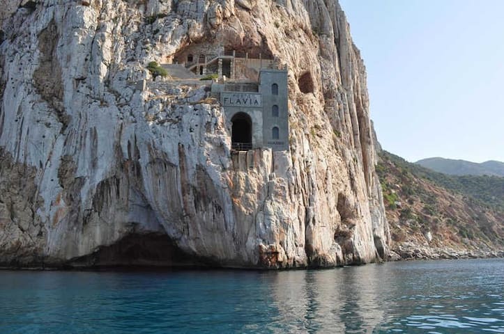
You see it appear halfway up, magically suspended in the air, like in an adventure novel. It is Porto Flavia, halfway between a commercial port and a futuristic architectural work that revolutionized engineering in the early twentieth century. It is located in the district of Masua, in the territory of Iglesias, and it is the most visible extremity of a complex of underground tunnels that end in a construction carved out of the rock face. It got its name from Cesare Vecelli, 'father' of the mine, who named it after his daughter (Flavia). The structure was used as a boarding system for directly transporting the extremely heavy minerals that were lowered onto the anchored vessels on the turquoise sea.
Lo vedi sbucare a mezz’altezza, magicamente sospeso nell’aria a richiamare un romanzo d’avventura. È Porto Flavia a metà tra uno scalo commerciale e una avveniristica opera architettonica che rivoluzionò l’ingegneria dei primi del Novecento. Si erge nella frazione di Masua, nel territorio di Iglesias, ed è l’estremità più visibile di un complesso di gallerie sotterranee che terminano in una costruzione intagliata nella parete rocciosa. Il nome gli venne dato da Cesare Vecelli, il ‘padre’ della miniera che la chiamò come sua figlia (Flavia). La struttura venne utilizzata come sistema di imbarco per trasportare direttamente sul mare i pesantissimi minerali che venivano calati sulle imbarcazioni alla fonda sul mare turchese.
Sentiero Per Porto Flavia
Sentiero Per Porto FlaviaYou see it appear halfway up, magically suspended in the air, like in an adventure novel. It is Porto Flavia, halfway between a commercial port and a futuristic architectural work that revolutionized engineering in the early twentieth century. It is located in the district of Masua, in the territory of Iglesias, and it is the most visible extremity of a complex of underground tunnels that end in a construction carved out of the rock face. It got its name from Cesare Vecelli, 'father' of the mine, who named it after his daughter (Flavia). The structure was used as a boarding system for directly transporting the extremely heavy minerals that were lowered onto the anchored vessels on the turquoise sea.
Lo vedi sbucare a mezz’altezza, magicamente sospeso nell’aria a richiamare un romanzo d’avventura. È Porto Flavia a metà tra uno scalo commerciale e una avveniristica opera architettonica che rivoluzionò l’ingegneria dei primi del Novecento. Si erge nella frazione di Masua, nel territorio di Iglesias, ed è l’estremità più visibile di un complesso di gallerie sotterranee che terminano in una costruzione intagliata nella parete rocciosa. Il nome gli venne dato da Cesare Vecelli, il ‘padre’ della miniera che la chiamò come sua figlia (Flavia). La struttura venne utilizzata come sistema di imbarco per trasportare direttamente sul mare i pesantissimi minerali che venivano calati sulle imbarcazioni alla fonda sul mare turchese.
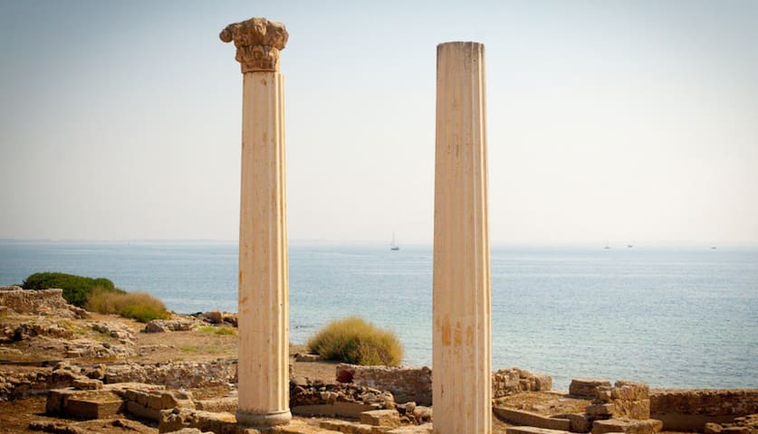
A Nuragic settlement, a Phoenician centre of commerce, a Carthaginian fortress, a Roman urbs, a Byzantine administrative centre and capital of Arborea: in Tharros, you will find more than two thousand years of history. The ruins of the ancient city, founded in the 8th century BC and abandoned in the 11th century AD, are located on the southern extremity of the Sinis peninsula, in the territory of Cabras. The ‘outdoor museum’ is a natural amphitheatre overlooking the sea. On its borders, there is the isthmus of Capo San Marco as well as the hills of the village of San Giovanni di Sinis and su Murru Mannu (big face), on top of which you will find the oldest historical evidence: the remains of the Nuragic village, abandoned before the arrival of the Phoenicians. There are also the remains of two nuraghi on the promontory of San Marco and another is thought to be at the base of the Tower of San Giovanni, one of the three – in addition to the ‘Old Tower’ and Turr’e Seu – built to defend the Gulf from the Spanish Crown. Not only a sightseeing point but also a beautiful beach with crystal clear waters awaits you.
Insediamento nuragico, emporio fenicio, fortezza cartaginese, urbs romana, capoluogo bizantino e capitale arborense: a Tharros scoprirai oltre due millenni di storia. Le rovine dell’antica città, fondata nell’VIII secolo a.C. e abbandonata nell’XI d.C., sorgono nella propaggine meridionale della penisola del Sinis, nel territorio di Cabras. Il ‘museo all’aria è un anfiteatro naturale affacciato sul mare e delimitato dall’istmo di capo san Marco e dai colli della borgata di San Giovanni di Sinis e di su Murru Mannu (grande muso), in cima al quale troverai la testimonianza più antica, i resti del villaggio nuragico, abbandonato prima dell’avvento dei fenici. Resti di due nuraghi spuntano anche sul promontorio di san Marco, un altro è ipotizzato alla base della torre di san Giovanni, una delle tre – oltre a ‘torre vecchia’ e Turr’e Seu - erette a difesa del golfo dalla Corona spagnola (XVI secolo). Non solo un punto turistico ma anche una bellissima spiaggia con acque cristalline ti aspetta.
66 명의 현지인이 추천하는 곳
San Giovanni di Sinis
A Nuragic settlement, a Phoenician centre of commerce, a Carthaginian fortress, a Roman urbs, a Byzantine administrative centre and capital of Arborea: in Tharros, you will find more than two thousand years of history. The ruins of the ancient city, founded in the 8th century BC and abandoned in the 11th century AD, are located on the southern extremity of the Sinis peninsula, in the territory of Cabras. The ‘outdoor museum’ is a natural amphitheatre overlooking the sea. On its borders, there is the isthmus of Capo San Marco as well as the hills of the village of San Giovanni di Sinis and su Murru Mannu (big face), on top of which you will find the oldest historical evidence: the remains of the Nuragic village, abandoned before the arrival of the Phoenicians. There are also the remains of two nuraghi on the promontory of San Marco and another is thought to be at the base of the Tower of San Giovanni, one of the three – in addition to the ‘Old Tower’ and Turr’e Seu – built to defend the Gulf from the Spanish Crown. Not only a sightseeing point but also a beautiful beach with crystal clear waters awaits you.
Insediamento nuragico, emporio fenicio, fortezza cartaginese, urbs romana, capoluogo bizantino e capitale arborense: a Tharros scoprirai oltre due millenni di storia. Le rovine dell’antica città, fondata nell’VIII secolo a.C. e abbandonata nell’XI d.C., sorgono nella propaggine meridionale della penisola del Sinis, nel territorio di Cabras. Il ‘museo all’aria è un anfiteatro naturale affacciato sul mare e delimitato dall’istmo di capo san Marco e dai colli della borgata di San Giovanni di Sinis e di su Murru Mannu (grande muso), in cima al quale troverai la testimonianza più antica, i resti del villaggio nuragico, abbandonato prima dell’avvento dei fenici. Resti di due nuraghi spuntano anche sul promontorio di san Marco, un altro è ipotizzato alla base della torre di san Giovanni, una delle tre – oltre a ‘torre vecchia’ e Turr’e Seu - erette a difesa del golfo dalla Corona spagnola (XVI secolo). Non solo un punto turistico ma anche una bellissima spiaggia con acque cristalline ti aspetta.
U pàize is a Ligurian enclave in Sardinia: it preserves the language and culture of its founders, the fisherman families originally from Pegli, and from the Tunisian island of Tabarka (where they lived since the 16th century). The tabarchini in 1738 obtained permission from King Carlo Emanuele III to colonize the island of San Pietro, which was uninhabited and known as belonging to 'the sparrow-hawks' since the Phoenician settlement (8th century BC), followed by the Carthaginians, with temple and necropolis . The same fishermen, 40 years later, also founded Calasetta on the facing island of Sant'Antioco.
Carloforte, still closely linked to Pegli and Genoa, is the only centre of the island, with six thousand inhabitants: it will captivate you with narrow streets and alleys that climb up a slight slope, with colourful sea views, marina and ancient defensive fortifications, of which remain watch towers and stretches of walls with forts, including the Lion's Gate. The architecture of the village, which is in the club of the most beautiful in Italy, we note the early 20th century a Palassiu , today the Giuseppe Cavallera cineteatro (cinema and theatre), and the church of the Madonna del naufrago, which houses the wooden statue revered by the tabarchini, a symbol of faith and solidarity union of the community.
U pàize è un enclave ligure in Sardegna: conserva lingua e cultura dei fondatori, le famiglie di pescatori originarie di Pegli, e provenienti dall’isola tunisina di Tabarka (dove risiedevano dal XVI secolo). I tabarchini nel 1738 ottennero dal re Carlo Emanuele III il permesso di colonizzare l’isola di san Pietro, disabitata e detta ‘degli sparvieri’ sin dai tempi dell’insediamento fenicio (VIII secolo a.C.), cui seguì quello punico, con tempio e necropoli. Gli stessi pescatori, 40 anni dopo, avrebbero fondato anche Calasetta sulla prospiciente isola di sant’Antioco.
Carloforte, tuttora strettamente legato a Pegli e Genova, è l’unico centro dell’isola, con seimila abitanti: ti conquisterà con viuzze e vicoli che si inerpicano su un lieve pendio, con scorci colorati e vedute sul mare, con porticciolo e antiche fortificazioni difensive, di cui restano torri d’avvistamento e tratti di mura con fortini, compresa la Porta del Leone. Nell’architettura del borgo, inserito nel club dei più belli d’Italia, si distinguono u Palassiu di inizio Novecento, oggi cineteatro Giuseppe Cavallera, e la chiesa della Madonna del naufrago, che accoglie la statua lignea venerata dai tabarchini, simbolo di fede e unione solidale della comunità.
90 명의 현지인이 추천하는 곳
Carloforte
U pàize is a Ligurian enclave in Sardinia: it preserves the language and culture of its founders, the fisherman families originally from Pegli, and from the Tunisian island of Tabarka (where they lived since the 16th century). The tabarchini in 1738 obtained permission from King Carlo Emanuele III to colonize the island of San Pietro, which was uninhabited and known as belonging to 'the sparrow-hawks' since the Phoenician settlement (8th century BC), followed by the Carthaginians, with temple and necropolis . The same fishermen, 40 years later, also founded Calasetta on the facing island of Sant'Antioco.
Carloforte, still closely linked to Pegli and Genoa, is the only centre of the island, with six thousand inhabitants: it will captivate you with narrow streets and alleys that climb up a slight slope, with colourful sea views, marina and ancient defensive fortifications, of which remain watch towers and stretches of walls with forts, including the Lion's Gate. The architecture of the village, which is in the club of the most beautiful in Italy, we note the early 20th century a Palassiu , today the Giuseppe Cavallera cineteatro (cinema and theatre), and the church of the Madonna del naufrago, which houses the wooden statue revered by the tabarchini, a symbol of faith and solidarity union of the community.
U pàize è un enclave ligure in Sardegna: conserva lingua e cultura dei fondatori, le famiglie di pescatori originarie di Pegli, e provenienti dall’isola tunisina di Tabarka (dove risiedevano dal XVI secolo). I tabarchini nel 1738 ottennero dal re Carlo Emanuele III il permesso di colonizzare l’isola di san Pietro, disabitata e detta ‘degli sparvieri’ sin dai tempi dell’insediamento fenicio (VIII secolo a.C.), cui seguì quello punico, con tempio e necropoli. Gli stessi pescatori, 40 anni dopo, avrebbero fondato anche Calasetta sulla prospiciente isola di sant’Antioco.
Carloforte, tuttora strettamente legato a Pegli e Genova, è l’unico centro dell’isola, con seimila abitanti: ti conquisterà con viuzze e vicoli che si inerpicano su un lieve pendio, con scorci colorati e vedute sul mare, con porticciolo e antiche fortificazioni difensive, di cui restano torri d’avvistamento e tratti di mura con fortini, compresa la Porta del Leone. Nell’architettura del borgo, inserito nel club dei più belli d’Italia, si distinguono u Palassiu di inizio Novecento, oggi cineteatro Giuseppe Cavallera, e la chiesa della Madonna del naufrago, che accoglie la statua lignea venerata dai tabarchini, simbolo di fede e unione solidale della comunità.
A town of coloured houses and restaurants that inebriate the air with inviting scents: the seaside soul of Sant'Antioco. This well-known town of the Sulcis archipelago, populated by eleven thousand residents and tens of thousands of visitors in the summer, is the main centre of the largest island of Sardinia, which is connected by an artificial isthmus, built perhaps by the Carthaginians and completed by the Romans.
Porticciolo, case colorate e ristoranti che inebriano l’aria di invitanti profumi: è l’anima di mare di Sant’Antioco. La rinomata cittadina dell’arcipelago del Sulcis, popolata da undicimila residenti e decine di migliaia di visitatori in estate, è il centro principale della maggiore isola della Sardegna, cui è collegata da un istmo artificiale, costruito forse dai punici e perfezionato dai romani.
33 명의 현지인이 추천하는 곳
Sant'Antioco
A town of coloured houses and restaurants that inebriate the air with inviting scents: the seaside soul of Sant'Antioco. This well-known town of the Sulcis archipelago, populated by eleven thousand residents and tens of thousands of visitors in the summer, is the main centre of the largest island of Sardinia, which is connected by an artificial isthmus, built perhaps by the Carthaginians and completed by the Romans.
Porticciolo, case colorate e ristoranti che inebriano l’aria di invitanti profumi: è l’anima di mare di Sant’Antioco. La rinomata cittadina dell’arcipelago del Sulcis, popolata da undicimila residenti e decine di migliaia di visitatori in estate, è il centro principale della maggiore isola della Sardegna, cui è collegata da un istmo artificiale, costruito forse dai punici e perfezionato dai romani.
Here, there are the humble workers' cottages, the luxurious management building, the mining and processing sites, the directional locations and service areas. Amongst the monuments of industrial archaeology of Montevecchio, immersed in the territory of Arbus and Guspini, you can take a historical-cultural tour to discover a “ghost world” evoked by a complex of mines, a few hundred metres from the Piscinas dunes and close to other beaches on the Costa Verde. The mining activities of the site - being one of the eight that comprise the geominerary park of Sardinia and a symbol of the UNESCO Geoparks - has endured almost a century and a half, since 1848 when King Carlo Alberto granted the first licence to Giovanni Antonio Sanna, who devised the “deal of the century”, until 1991, the year when it finally closed following decades of economic crises. It saw times of flourishment and great development, aided by technological innovations - having 1,100 workers in 1865, it was the most important mine in the Kingdom of Italy.
Dalle umili case degli operai al lussuoso palazzo della direzione, passando per cantieri di estrazione e lavorazione, sedi dirigenziali e di servizi. Tra i monumenti di archeologia industriale di Montevecchio, immersi nel territorio di Arbus e Guspini, compirai un tour storico-culturale alla scoperta di un ‘mondo fantasma’ rievocato da un complesso di miniere dismesse, a poche centinaia di metri dalle dune di Piscinas e vicino ad altre spiagge della Costa Verde. L’attività estrattiva del sito, uno degli otto che compongono il parco geominerario della Sardegna - simbolo dei Geoparks dell’Unesco – è durata quasi un secolo e mezzo, dal 1848, quando re Carlo Alberto concesse lo sfruttamento per primo a Giovanni Antonio Sanna, ideatore dell’‘affare del secolo’, sino al 1991, anno della definitiva chiusura dopo decenni di crisi. Visse tempi fiorenti e di sviluppo, supportati da innovazioni tecnologiche: nel 1865, con 1100 operai, era la miniera più importante del Regno d’Italia.
22 명의 현지인이 추천하는 곳
Miniera di Montevecchio
Piazzale RolandiHere, there are the humble workers' cottages, the luxurious management building, the mining and processing sites, the directional locations and service areas. Amongst the monuments of industrial archaeology of Montevecchio, immersed in the territory of Arbus and Guspini, you can take a historical-cultural tour to discover a “ghost world” evoked by a complex of mines, a few hundred metres from the Piscinas dunes and close to other beaches on the Costa Verde. The mining activities of the site - being one of the eight that comprise the geominerary park of Sardinia and a symbol of the UNESCO Geoparks - has endured almost a century and a half, since 1848 when King Carlo Alberto granted the first licence to Giovanni Antonio Sanna, who devised the “deal of the century”, until 1991, the year when it finally closed following decades of economic crises. It saw times of flourishment and great development, aided by technological innovations - having 1,100 workers in 1865, it was the most important mine in the Kingdom of Italy.
Dalle umili case degli operai al lussuoso palazzo della direzione, passando per cantieri di estrazione e lavorazione, sedi dirigenziali e di servizi. Tra i monumenti di archeologia industriale di Montevecchio, immersi nel territorio di Arbus e Guspini, compirai un tour storico-culturale alla scoperta di un ‘mondo fantasma’ rievocato da un complesso di miniere dismesse, a poche centinaia di metri dalle dune di Piscinas e vicino ad altre spiagge della Costa Verde. L’attività estrattiva del sito, uno degli otto che compongono il parco geominerario della Sardegna - simbolo dei Geoparks dell’Unesco – è durata quasi un secolo e mezzo, dal 1848, quando re Carlo Alberto concesse lo sfruttamento per primo a Giovanni Antonio Sanna, ideatore dell’‘affare del secolo’, sino al 1991, anno della definitiva chiusura dopo decenni di crisi. Visse tempi fiorenti e di sviluppo, supportati da innovazioni tecnologiche: nel 1865, con 1100 operai, era la miniera più importante del Regno d’Italia.
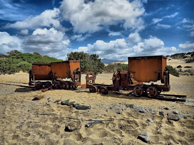
Its name comes from gurturgiu, a species of vulture, or from 'inghiottitoio' (ponor), perhaps relative to ancient excavations. In both cases, it fully defines the wild setting in which it is located. Set between rugged mountains, Ingurtosu, a district of Arbus, which is ten kilometres away, is located in the valley of Is Animas, which stretches as fare as the sand dunes of Piscinas, a gem of the Costa Verde, where wagons used for transporting extracted material are abandoned. For over a century, it was the business centre of two mines, that of the same name and Gennamari, which were part of the Montevecchio complex. Today it is a deserted village in ruins.
Il nome deriverebbe da gurturgiu, una specie di avvoltoio, o da ‘inghiottitoio’, forse riferito a scavi antichi. In entrambi i casi, definisce in pieno il quadro selvaggio in cui sorge. Incastonato tra aspre montagne, Ingurtosu, frazione di Arbus, da cui dista dieci chilometri, si trova nella valle de Is Animas, che si spinge sino alle dune di Piscinas, gioiello della Costa Verde, dove sono abbandonati vagoni usati per il trasporto di materiale estratto. È stato per oltre un secolo il centro direzionale di due miniere, quella omonima e Gennamari, che facevano parte del complesso di Montevecchio. Oggi è un villaggio diroccato e deserto.
8 명의 현지인이 추천하는 곳
Ingurtosu
Its name comes from gurturgiu, a species of vulture, or from 'inghiottitoio' (ponor), perhaps relative to ancient excavations. In both cases, it fully defines the wild setting in which it is located. Set between rugged mountains, Ingurtosu, a district of Arbus, which is ten kilometres away, is located in the valley of Is Animas, which stretches as fare as the sand dunes of Piscinas, a gem of the Costa Verde, where wagons used for transporting extracted material are abandoned. For over a century, it was the business centre of two mines, that of the same name and Gennamari, which were part of the Montevecchio complex. Today it is a deserted village in ruins.
Il nome deriverebbe da gurturgiu, una specie di avvoltoio, o da ‘inghiottitoio’, forse riferito a scavi antichi. In entrambi i casi, definisce in pieno il quadro selvaggio in cui sorge. Incastonato tra aspre montagne, Ingurtosu, frazione di Arbus, da cui dista dieci chilometri, si trova nella valle de Is Animas, che si spinge sino alle dune di Piscinas, gioiello della Costa Verde, dove sono abbandonati vagoni usati per il trasporto di materiale estratto. È stato per oltre un secolo il centro direzionale di due miniere, quella omonima e Gennamari, che facevano parte del complesso di Montevecchio. Oggi è un villaggio diroccato e deserto.
In the Medio Campidano area, between Oristano and Cagliari, there is a destination, very popular with trekking enthusiasts, that invites you to travel over its green slopes along trails taking you to the summit, where you can enjoy breathtaking views.
Arkù indicates the arched shape of the summit that, when seen from Piscinas and Scivu, looks like a dolomitic tower. The mighty Monte Arcuentu, a popular trekking destination, is part of a mountain range that runs parallel for eight kilometres to the beaches of the wild and wonderful Costa Verde. It is part of the territory of Arbus, which is eleven kilometres away, and it is near the Montevecchio mines, once the economic reference point of the area and today an open air museum of industrial archaeology. From the summit of Arcuentu, the horizon disappears before your eyes: you will admire landscapes of the nearby mountains of Arci and Linas, from the gulf of Oristano to the Costa Verde and from the valley of Campidano to the peaks of Montiferru, Sette Fratelli and Gennargentu.
The rocks - tuff and basalt of volcanic origin - alternate with aiguilles and towers as you climb. Along the slopes, there are flowing torrents that have created deep, narrow valleys. The Italian Alpine Club's (Club Alpino Italiano - CAI) easy trail leaves from the mines and will take you to the summit, at 785 metres, in a spectacular landscape. Along the trail, you will be walking through woods of holm oaks and Mediterranean scrub, from broom to orchids. The prayers and meditation of Fra' Nazareno and Fra' Lorenzo, of the 20th century, are linked to this place. Fra' Nazareno's hut is situated along the trail and Fra' Lorenzo spent a month here every year for thirty years. It is probable that, while walking, through the vegetation and rocks, you will see deer, wild boar, weasels, hares, martens and foxes. At the top, you will witness the flight of the golden eagle, the peregrine falcon, the buzzard and the Eurasian sparrowhawk, while in the background you will hear the song of chaffinches, robins and woodpeckers.
Nel Medio Campidano, tra Oristano e Cagliari, c’è una meta ambita dagli appassionati di trekking, che ti invita ad avventurarti sulle sue verdi pendici, dove i sentieri ti porteranno fino alla cima, a godere di panorami mozzafiato.
Arkù indica la forma arcuata della vetta, che, vista da Piscinas e Scivu, pare un torrione dolomitico. L’imponente monte Arcuentu, ambita meta di trekking, fa parte di una catena montuosa che corre parallela per otto chilometri alle spiagge della selvaggia e stupenda Costa Verde. Rientra nel territorio di Arbus, da cui dista undici chilometri, e sta vicino alle miniere di Montevecchio, un tempo riferimento economico della zona, oggi museo di archeologia industriale all’aria aperta. Dalla cima dell’Arcuentu l’orizzonte si perde a vista d’occhio: ammirerai panorami sui vicini monti Arci e Linas, dal golfo di Oristano alla Costa Verde, dalla vallata del Campidano sino alle vette di Montiferru, Sette Fratelli e Gennargentu.
Le rocce - tufi e basalti di origine vulcanica - si alternano in guglie e torrioni nella scalata. Lungo le pendici scorrono torrenti che hanno scavato valli strette e profonde. L’agevole sentiero del Club alpino italiano (Cai), partendo dalle miniere, ti porterà in vetta, a 785 metri, in un paesaggio spettacolare. Nel percorso, sarai avvolto da boschi di lecci e macchia mediterranea, da ginestre e orchidee. Al luogo sono legate, nel XX secolo, preghiere e meditazioni di Fra’ Nazareno, la cui capanna è lungo l’itinerario, e del Fra’ Lorenzo, che vi passò un mese l’anno per trent’anni. È probabile che passeggiando vedrai, tra vegetazione e rocce, cervi, cinghiali, donnole, lepri, martore e volpi. In cima osserverai il volo di aquila reale, falco pellegrino, poiana e sparviero, in sottofondo percepirai il canto di fringuelli, pettirossi e picchi.
7 명의 현지인이 추천하는 곳
Monte Arcuentu
Strada Provinciale 65In the Medio Campidano area, between Oristano and Cagliari, there is a destination, very popular with trekking enthusiasts, that invites you to travel over its green slopes along trails taking you to the summit, where you can enjoy breathtaking views.
Arkù indicates the arched shape of the summit that, when seen from Piscinas and Scivu, looks like a dolomitic tower. The mighty Monte Arcuentu, a popular trekking destination, is part of a mountain range that runs parallel for eight kilometres to the beaches of the wild and wonderful Costa Verde. It is part of the territory of Arbus, which is eleven kilometres away, and it is near the Montevecchio mines, once the economic reference point of the area and today an open air museum of industrial archaeology. From the summit of Arcuentu, the horizon disappears before your eyes: you will admire landscapes of the nearby mountains of Arci and Linas, from the gulf of Oristano to the Costa Verde and from the valley of Campidano to the peaks of Montiferru, Sette Fratelli and Gennargentu.
The rocks - tuff and basalt of volcanic origin - alternate with aiguilles and towers as you climb. Along the slopes, there are flowing torrents that have created deep, narrow valleys. The Italian Alpine Club's (Club Alpino Italiano - CAI) easy trail leaves from the mines and will take you to the summit, at 785 metres, in a spectacular landscape. Along the trail, you will be walking through woods of holm oaks and Mediterranean scrub, from broom to orchids. The prayers and meditation of Fra' Nazareno and Fra' Lorenzo, of the 20th century, are linked to this place. Fra' Nazareno's hut is situated along the trail and Fra' Lorenzo spent a month here every year for thirty years. It is probable that, while walking, through the vegetation and rocks, you will see deer, wild boar, weasels, hares, martens and foxes. At the top, you will witness the flight of the golden eagle, the peregrine falcon, the buzzard and the Eurasian sparrowhawk, while in the background you will hear the song of chaffinches, robins and woodpeckers.
Nel Medio Campidano, tra Oristano e Cagliari, c’è una meta ambita dagli appassionati di trekking, che ti invita ad avventurarti sulle sue verdi pendici, dove i sentieri ti porteranno fino alla cima, a godere di panorami mozzafiato.
Arkù indica la forma arcuata della vetta, che, vista da Piscinas e Scivu, pare un torrione dolomitico. L’imponente monte Arcuentu, ambita meta di trekking, fa parte di una catena montuosa che corre parallela per otto chilometri alle spiagge della selvaggia e stupenda Costa Verde. Rientra nel territorio di Arbus, da cui dista undici chilometri, e sta vicino alle miniere di Montevecchio, un tempo riferimento economico della zona, oggi museo di archeologia industriale all’aria aperta. Dalla cima dell’Arcuentu l’orizzonte si perde a vista d’occhio: ammirerai panorami sui vicini monti Arci e Linas, dal golfo di Oristano alla Costa Verde, dalla vallata del Campidano sino alle vette di Montiferru, Sette Fratelli e Gennargentu.
Le rocce - tufi e basalti di origine vulcanica - si alternano in guglie e torrioni nella scalata. Lungo le pendici scorrono torrenti che hanno scavato valli strette e profonde. L’agevole sentiero del Club alpino italiano (Cai), partendo dalle miniere, ti porterà in vetta, a 785 metri, in un paesaggio spettacolare. Nel percorso, sarai avvolto da boschi di lecci e macchia mediterranea, da ginestre e orchidee. Al luogo sono legate, nel XX secolo, preghiere e meditazioni di Fra’ Nazareno, la cui capanna è lungo l’itinerario, e del Fra’ Lorenzo, che vi passò un mese l’anno per trent’anni. È probabile che passeggiando vedrai, tra vegetazione e rocce, cervi, cinghiali, donnole, lepri, martore e volpi. In cima osserverai il volo di aquila reale, falco pellegrino, poiana e sparviero, in sottofondo percepirai il canto di fringuelli, pettirossi e picchi.
For the lovers of archaeology, Arbus offers interesting nuragic finds. The nuraghe of Cugui is one of the most original in Sardinia: located on a hill in a panoramic point towards Fluminimaggiore, it is easily reachable from Canau place, known for its spring.
It has got three towers and only one of that is accessible from a not so high entrance. From it, it is possible to have a view of Arbus, Mount Linas and a part of Gonnosfanadiga.
Per gli amanti dell’archeologia, Arbus offre interessanti ritrovamenti di epoca nuragica. Il nuraghe Cugui è uno dei nuraghe più originali di tutta la Sardegna: posto in posizione panoramica su di una collina in direzione Fluminimaggiore, è facilmente accessibile dalla zona di Canau, conosciuta grazie alla sua sorgente.
Presenta una struttura a tre torri di cui solo una è accessibile, anche se da un'apertura non particolarmente alta. Dalla sua collocazione è possibile vedere tutto il paese di Arbus, la catena del Monte Linas ed una parte dell'abitato di Gonnosfanadiga.
Nuraghe Cugui
For the lovers of archaeology, Arbus offers interesting nuragic finds. The nuraghe of Cugui is one of the most original in Sardinia: located on a hill in a panoramic point towards Fluminimaggiore, it is easily reachable from Canau place, known for its spring.
It has got three towers and only one of that is accessible from a not so high entrance. From it, it is possible to have a view of Arbus, Mount Linas and a part of Gonnosfanadiga.
Per gli amanti dell’archeologia, Arbus offre interessanti ritrovamenti di epoca nuragica. Il nuraghe Cugui è uno dei nuraghe più originali di tutta la Sardegna: posto in posizione panoramica su di una collina in direzione Fluminimaggiore, è facilmente accessibile dalla zona di Canau, conosciuta grazie alla sua sorgente.
Presenta una struttura a tre torri di cui solo una è accessibile, anche se da un'apertura non particolarmente alta. Dalla sua collocazione è possibile vedere tutto il paese di Arbus, la catena del Monte Linas ed una parte dell'abitato di Gonnosfanadiga.
In the central-southern part of Sardinia, deep inside the Medio Campidano area, a constantly spectacular sight is that of one of the highest waterfalls on the Island, in a natural environment of unparalleled beauty.
A sheet of water cuts through the rock and passes through a lush, scented forest. It is the image that nature has painted around Villacidro, in the Medio Campidano area, embedding it in one of the most spectacular waterfalls in Sardinia, to the point that Gabriele D'Annunzio sang its praises in a sonnet composed during one of his visits to the Island in 1882.
Sa Spendula, name of the locality in which it is situated, means 'the cascade': it is the sudden fall of Rio Coxinas, which originates at Santu Miali (in the picturesque park of Monte Linas), in three consecutive water drops with a maximum 60-metre high altitude gap. The waters form three natural pools in the same number of fall areas and flow into a gorge of special natural value, dominated by a granitic aiguille, known as Campanas de Sisinni Conti.
Nella parte centro-meridionale della Sardegna, in pieno Medio Campidano, dà perennemente spettacolo una delle cascate più ‘alte’ dell’Isola, all’interno di un contesto naturalistico d’incomparabile bellezza.
Una lama d’acqua fende la roccia e trapassa una foresta rigogliosa e profumata. È l’immagine che la natura ha dipinto nei dintorni di Villacidro, nel Medio Campidano, imprimendola in una delle cascate più spettacolari della Sardegna, tanto da essere decantata da Gabriele D'Annunzio in un sonetto composto in occasione di una sua visita nell’Isola nel 1882.
Sa Spendula, nome della località che la ospita, significa appunto ‘la cascata’: è l’improvvisa caduta del rio Coxinas, che prende origine dalle punte Santu Miali (nel suggestivo parco del monte Linas), in tre salti consecutivi per un’altezza massima di 60 metri di dislivello. Le acque formano tre piscine naturali in altrettanti punti di caduta e confluiscono in una gola di particolare pregio naturalistico, dominata da una guglia granitica, detta Campanas de Sisinni Conti.
7 명의 현지인이 추천하는 곳
Sa Spendula 2.0
Via Sa SpendulaIn the central-southern part of Sardinia, deep inside the Medio Campidano area, a constantly spectacular sight is that of one of the highest waterfalls on the Island, in a natural environment of unparalleled beauty.
A sheet of water cuts through the rock and passes through a lush, scented forest. It is the image that nature has painted around Villacidro, in the Medio Campidano area, embedding it in one of the most spectacular waterfalls in Sardinia, to the point that Gabriele D'Annunzio sang its praises in a sonnet composed during one of his visits to the Island in 1882.
Sa Spendula, name of the locality in which it is situated, means 'the cascade': it is the sudden fall of Rio Coxinas, which originates at Santu Miali (in the picturesque park of Monte Linas), in three consecutive water drops with a maximum 60-metre high altitude gap. The waters form three natural pools in the same number of fall areas and flow into a gorge of special natural value, dominated by a granitic aiguille, known as Campanas de Sisinni Conti.
Nella parte centro-meridionale della Sardegna, in pieno Medio Campidano, dà perennemente spettacolo una delle cascate più ‘alte’ dell’Isola, all’interno di un contesto naturalistico d’incomparabile bellezza.
Una lama d’acqua fende la roccia e trapassa una foresta rigogliosa e profumata. È l’immagine che la natura ha dipinto nei dintorni di Villacidro, nel Medio Campidano, imprimendola in una delle cascate più spettacolari della Sardegna, tanto da essere decantata da Gabriele D'Annunzio in un sonetto composto in occasione di una sua visita nell’Isola nel 1882.
Sa Spendula, nome della località che la ospita, significa appunto ‘la cascata’: è l’improvvisa caduta del rio Coxinas, che prende origine dalle punte Santu Miali (nel suggestivo parco del monte Linas), in tre salti consecutivi per un’altezza massima di 60 metri di dislivello. Le acque formano tre piscine naturali in altrettanti punti di caduta e confluiscono in una gola di particolare pregio naturalistico, dominata da una guglia granitica, detta Campanas de Sisinni Conti.
One of Sardinia's most important monuments dating back the Roman period is located in a lush valley in the Iglesias area, a site that emerged as a Nuragic sanctuary, also used in the Carthaginian and Punic-Hellenistic era.
An access flight of steps and a podium adorned by elegant columns delimits the votive areas, in a context of perfect alignment. These ruins of the Temple of Antas are substantial and have reached the present day surrounded by nature, taking on the appearance of a silent Avalon in the springtime.
The sanctuary was built from local limestone and is located in an evocative valley, in the Fluminimaggiore territory, dominated by Mount Conca s'Omu.
In una vallata del sud-ovest della Sardegna risalta un monumento fondamentale dell’età romana nell’Isola, già santuario nuragico e in auge anche in epoca punica.
Nella quiete, lontano da centri abitati, è incastonato tra i rilievi dell’Iglesiente, in mezzo a una valle dominata dal monte Conca s’Omu, che in primavera assume l’aspetto di una silenziosa Avalon, ammantata da un prato di margherite bianche e profumata dal rosmarino.
45 명의 현지인이 추천하는 곳
Temple of Antas
SS126One of Sardinia's most important monuments dating back the Roman period is located in a lush valley in the Iglesias area, a site that emerged as a Nuragic sanctuary, also used in the Carthaginian and Punic-Hellenistic era.
An access flight of steps and a podium adorned by elegant columns delimits the votive areas, in a context of perfect alignment. These ruins of the Temple of Antas are substantial and have reached the present day surrounded by nature, taking on the appearance of a silent Avalon in the springtime.
The sanctuary was built from local limestone and is located in an evocative valley, in the Fluminimaggiore territory, dominated by Mount Conca s'Omu.
In una vallata del sud-ovest della Sardegna risalta un monumento fondamentale dell’età romana nell’Isola, già santuario nuragico e in auge anche in epoca punica.
Nella quiete, lontano da centri abitati, è incastonato tra i rilievi dell’Iglesiente, in mezzo a una valle dominata dal monte Conca s’Omu, che in primavera assume l’aspetto di una silenziosa Avalon, ammantata da un prato di margherite bianche e profumata dal rosmarino.
Next to the Iglesiente mines and near the Costa Verde, in the south-western part of Sardinia, there is an unexpected Karst cavity that stands out for its natural beauty, archaeological importance and speleological interest.
Step into the magic that lies under the ground in Iglesiente, from the red rocks, blue lakes, bright white stalactites and stalagmites to the sparkling transparency of the crystals. The grottoes of su Mannau, in the territory of Fluminimaggiore, are a Karst complex "sculpted" 540 million years ago, and still "living": the calcareous formations are constantly evolving. The cavern winds into the heart of the earth for 8 kilometres, with two main branches: the left originating from the River Placido, with spectacular tunnels and rooms, and the right branch, larger and almost "horizontal", originating from the River Rapido.
Accanto alle miniere dell’Iglesiente e vicino alla Costa Verde, nella parte sud-occidentale della Sardegna, si apre una sorprendente cavità carsica: si caratterizza per bellezza naturalistica, importanza archeologica e interesse speleologico.
Ti immergerai nella magia che riposa nel sottosuolo dell’Iglesiente, tra sfumature rosse della roccia, laghetti blu, bianchissime stalattiti e stalagmiti e lucente trasparenza dei cristalli. Le grotte di su Mannau, nel territorio di Fluminimaggiore, sono un complesso carsico ‘scolpito’ 540 milioni di anni fa e ancora ‘vivo’: le formazioni calcaree sono in continua evoluzione. L’antro s’insinua per otto chilometri nel cuore della terra con due rami principali: quello sinistro originato dal fiume Placido, con spettacolari condotti e saloni, quello destro, il maggiore e quasi ‘orizzontale’, originato dal fiume Rapido.
48 명의 현지인이 추천하는 곳
수 만나우 동굴
Next to the Iglesiente mines and near the Costa Verde, in the south-western part of Sardinia, there is an unexpected Karst cavity that stands out for its natural beauty, archaeological importance and speleological interest.
Step into the magic that lies under the ground in Iglesiente, from the red rocks, blue lakes, bright white stalactites and stalagmites to the sparkling transparency of the crystals. The grottoes of su Mannau, in the territory of Fluminimaggiore, are a Karst complex "sculpted" 540 million years ago, and still "living": the calcareous formations are constantly evolving. The cavern winds into the heart of the earth for 8 kilometres, with two main branches: the left originating from the River Placido, with spectacular tunnels and rooms, and the right branch, larger and almost "horizontal", originating from the River Rapido.
Accanto alle miniere dell’Iglesiente e vicino alla Costa Verde, nella parte sud-occidentale della Sardegna, si apre una sorprendente cavità carsica: si caratterizza per bellezza naturalistica, importanza archeologica e interesse speleologico.
Ti immergerai nella magia che riposa nel sottosuolo dell’Iglesiente, tra sfumature rosse della roccia, laghetti blu, bianchissime stalattiti e stalagmiti e lucente trasparenza dei cristalli. Le grotte di su Mannau, nel territorio di Fluminimaggiore, sono un complesso carsico ‘scolpito’ 540 milioni di anni fa e ancora ‘vivo’: le formazioni calcaree sono in continua evoluzione. L’antro s’insinua per otto chilometri nel cuore della terra con due rami principali: quello sinistro originato dal fiume Placido, con spettacolari condotti e saloni, quello destro, il maggiore e quasi ‘orizzontale’, originato dal fiume Rapido.
On top of a hill of vulcanic origin, in the valley of Cixerri, in the southwestern part of Sardinia, stands an enchanting castle, which has always been a place of mysterious legends.
From sunrise to sunset, you can see its shadows growing longer across the valley. It rises up out of the Mediterranean scrub and it has three levels that blend harmoniously with the sloping ground. You will enter at a height of 150 metres through a door that was once defended by three towers joined together by a boundary wall. The central one still survives and has recently been renovated. Inside the defensive line, there was the village with dwellings, warehouses, stables, cisterns and mills. Halfway up, at about 200 metres, stands the formidable cistern tower, which provided a huge supply of water: not surprisingly, the name Acquafredda comes from a spring that flows from the rocks on the hillside. In the highest part (250 metres) stand the impressive walls of the fortified tower, the dwelling of the castellan, accessible via a drawbridge.
In cima a un colle di origine vulcanica, in mezzo alla valle del Cixerri, nella parte sud-occidentale della Sardegna, sorge un affascinante castello, da sempre luogo di misteriose leggende.
All’alba e al tramonto, vedrai le sue ombre allungarsi sulla vallata. Svetta fra la macchia mediterranea e si articola su tre livelli armonici con l’andamento del pendio. Entrerai a quota 150 metri attraverso una porta un tempo difesa da tre torri raccordate da una cinta muraria. Sopravvive quella centrale, di recente ristrutturata. All’interno della linea difensiva, si trovava il borgo con alloggi, magazzini, stalle, cisterne e mulini. A mezza costa, circa 200 metri, svetta la poderosa torre cisterna, che consentiva un’ingente scorta d’acqua: il nome Acquafredda, non a caso, deriva da una sorgente che sgorga dalle rocce del colle. Nella parte più alta (250 metri) si elevano le imponenti mura del mastio, abitazione del castellano, accessibile da un ponte levatoio.
7 명의 현지인이 추천하는 곳
Castello di Acquafredda
Km35 Strada Statale 293 di GibaOn top of a hill of vulcanic origin, in the valley of Cixerri, in the southwestern part of Sardinia, stands an enchanting castle, which has always been a place of mysterious legends.
From sunrise to sunset, you can see its shadows growing longer across the valley. It rises up out of the Mediterranean scrub and it has three levels that blend harmoniously with the sloping ground. You will enter at a height of 150 metres through a door that was once defended by three towers joined together by a boundary wall. The central one still survives and has recently been renovated. Inside the defensive line, there was the village with dwellings, warehouses, stables, cisterns and mills. Halfway up, at about 200 metres, stands the formidable cistern tower, which provided a huge supply of water: not surprisingly, the name Acquafredda comes from a spring that flows from the rocks on the hillside. In the highest part (250 metres) stand the impressive walls of the fortified tower, the dwelling of the castellan, accessible via a drawbridge.
In cima a un colle di origine vulcanica, in mezzo alla valle del Cixerri, nella parte sud-occidentale della Sardegna, sorge un affascinante castello, da sempre luogo di misteriose leggende.
All’alba e al tramonto, vedrai le sue ombre allungarsi sulla vallata. Svetta fra la macchia mediterranea e si articola su tre livelli armonici con l’andamento del pendio. Entrerai a quota 150 metri attraverso una porta un tempo difesa da tre torri raccordate da una cinta muraria. Sopravvive quella centrale, di recente ristrutturata. All’interno della linea difensiva, si trovava il borgo con alloggi, magazzini, stalle, cisterne e mulini. A mezza costa, circa 200 metri, svetta la poderosa torre cisterna, che consentiva un’ingente scorta d’acqua: il nome Acquafredda, non a caso, deriva da una sorgente che sgorga dalle rocce del colle. Nella parte più alta (250 metri) si elevano le imponenti mura del mastio, abitazione del castellano, accessibile da un ponte levatoio.
Food scene - Dove mangiare
In the highest part of the campsite, from which you can also get to see the sea, there is the restaurant with attached bar, where you can savor local specialties accompanied by excellent wines.
Nella parte più alta del campeggio, da cui si può arrivare a vedere anche il mare, si trova il ristorante con bar annesso, in cui potrete assaporare specialità locali accompagnate da ottimi vini.
Camping Sciopadroxiu
Strada Ingurtosu - PiscinasIn the highest part of the campsite, from which you can also get to see the sea, there is the restaurant with attached bar, where you can savor local specialties accompanied by excellent wines.
Nella parte più alta del campeggio, da cui si può arrivare a vedere anche il mare, si trova il ristorante con bar annesso, in cui potrete assaporare specialità locali accompagnate da ottimi vini.
The enchanting setting of the Costa Verde welcomes the Corsaro Nero restaurant in a still unspoiled natural landscape, the Chef elaborates the best of Sardinian cuisine interpreting and revisiting classics of the island tradition, menus are created ranging from roasts to grilled fish using the products of the territory.
La cornice incantevole della Costa Verde accoglie il Ristorante Corsaro Nero in un paesaggio naturalistico ancora incontaminato, lo Chef elabora il meglio della cucina sarda interpretando e rivisitando classici della tradizione isolana, vengono creati dei menù che spaziano dagli arrosti alle grigliate di pesce utilizzando i prodotti del territorio.
Il Corsaro Nero
The enchanting setting of the Costa Verde welcomes the Corsaro Nero restaurant in a still unspoiled natural landscape, the Chef elaborates the best of Sardinian cuisine interpreting and revisiting classics of the island tradition, menus are created ranging from roasts to grilled fish using the products of the territory.
La cornice incantevole della Costa Verde accoglie il Ristorante Corsaro Nero in un paesaggio naturalistico ancora incontaminato, lo Chef elabora il meglio della cucina sarda interpretando e rivisitando classici della tradizione isolana, vengono creati dei menù che spaziano dagli arrosti alle grigliate di pesce utilizzando i prodotti del territorio.
Sitting at the table is always a pleasure at the Oasis of the Deer. The dishes that Angela cooks with wisdom, respecting the millennial Sardinian tradition and with always fresh ingredients, bring us the flavors of a genuine Sardinia. Eating them while, beyond the window, you can see the deer going through the hills, or admiring the beach of Piscinas in all its splendor, fills the eyes as well as the palate. Around the farm we can see goats, which give some of the ingredients for Angela's recipes: milk, cheese, tasty meat, fresh cheese or spicy, perhaps accompanied by a full-bodied local wine. But the surprises of nature in Sardinia are many and we can find them, according to season, on our tables: mushrooms, asparagus, fruit and much more. The panorama is splendid and the cuisine is exquisite: ask who has already been!
Sedersi a tavola è sempre un piacere all'Oasi del Cervo. I piatti che Angela cucina con sapienza, nel rispetto della tradizione millenaria sarda e con ingredienti sempre freschi, ci portano i sapori di una Sardegna genuina. Mangiarli mentre, oltre la finestra, si vedono i cervi andare per colline, oppure ammirando in tutto il suo splendore la spiaggia di Piscinas, riempie gli occhi oltre che il palato. Attorno all'Agriturismo possiamo vedere le capre, che danno alcuni degli ingredienti per le ricette di Angela: il latte, il formaggio, la saporita carne, il fresco formaggio o quello piccante, accompagnato magari da un corposo vino locale. Ma le sorprese della natura in Sardegna sono tante e noi possiamo ritrovarle, secondo stagione, sulle nostre tavole: i funghi, gli asparagi, la frutta e tanto altro ancora. Il panorama è splendido e la cucina è squisita: chiedete a chi c'è già stato!
L'oasi del cervo
Vico I Genna FrongiaSitting at the table is always a pleasure at the Oasis of the Deer. The dishes that Angela cooks with wisdom, respecting the millennial Sardinian tradition and with always fresh ingredients, bring us the flavors of a genuine Sardinia. Eating them while, beyond the window, you can see the deer going through the hills, or admiring the beach of Piscinas in all its splendor, fills the eyes as well as the palate. Around the farm we can see goats, which give some of the ingredients for Angela's recipes: milk, cheese, tasty meat, fresh cheese or spicy, perhaps accompanied by a full-bodied local wine. But the surprises of nature in Sardinia are many and we can find them, according to season, on our tables: mushrooms, asparagus, fruit and much more. The panorama is splendid and the cuisine is exquisite: ask who has already been!
Sedersi a tavola è sempre un piacere all'Oasi del Cervo. I piatti che Angela cucina con sapienza, nel rispetto della tradizione millenaria sarda e con ingredienti sempre freschi, ci portano i sapori di una Sardegna genuina. Mangiarli mentre, oltre la finestra, si vedono i cervi andare per colline, oppure ammirando in tutto il suo splendore la spiaggia di Piscinas, riempie gli occhi oltre che il palato. Attorno all'Agriturismo possiamo vedere le capre, che danno alcuni degli ingredienti per le ricette di Angela: il latte, il formaggio, la saporita carne, il fresco formaggio o quello piccante, accompagnato magari da un corposo vino locale. Ma le sorprese della natura in Sardegna sono tante e noi possiamo ritrovarle, secondo stagione, sulle nostre tavole: i funghi, gli asparagi, la frutta e tanto altro ancora. Il panorama è splendido e la cucina è squisita: chiedete a chi c'è già stato!
In the Arbus Agriturismo L'Aquila you will find welcome and hospitality. The foods served in the L'Aquila farmhouse are traditional Sardinian cuisine with variations of the Arborese tradition. The quality of the product in our Sardinian dishes is guaranteed: the courses, always fresh and genuine, are made up of seasonal ingredients with the addition of love and passion, which give a touch of class to the dishes.
Nell’Agriturismo di Arbus l’Aquila troverete accoglienza e ospitalità. I cibi serviti nell’Agriturismo l’Aquila, sono quelli tradizionali della cucina sarda con le varianti della tradizione arburese. La qualità del prodotto nei nostri piatti di cucina sarda è garantita: le portate, sempre fresche e genuine, sono costituite da ingredienti stagionali con l’aggiunta di amore e passione, che danno un tocco di classe alle pietanze.
Agriturismo l'Aquila
In the Arbus Agriturismo L'Aquila you will find welcome and hospitality. The foods served in the L'Aquila farmhouse are traditional Sardinian cuisine with variations of the Arborese tradition. The quality of the product in our Sardinian dishes is guaranteed: the courses, always fresh and genuine, are made up of seasonal ingredients with the addition of love and passion, which give a touch of class to the dishes.
Nell’Agriturismo di Arbus l’Aquila troverete accoglienza e ospitalità. I cibi serviti nell’Agriturismo l’Aquila, sono quelli tradizionali della cucina sarda con le varianti della tradizione arburese. La qualità del prodotto nei nostri piatti di cucina sarda è garantita: le portate, sempre fresche e genuine, sono costituite da ingredienti stagionali con l’aggiunta di amore e passione, che danno un tocco di classe alle pietanze.
The cuisine proposed by the Chef uses the best of the island's production, with particular attention to
choice of raw materials interpreting and revisiting the classics of the Sardinian tradition and enhancing the
flavors of the seasons.
The simplicity of the roasts, fish dishes, products of the earth, the scents of wild herbs create menus that enhance the island's gastronomic tradition.
La cucina proposta dallo Chef utilizza il meglio della produzione dell’Isola, con particolare attenzione nella
scelta delle materie prime interpretando e rivisitando i classici della tradizione sarda ed esaltando i sapori delle stagioni.
La semplicità degli arrosti, dei piatti di pesce, i prodotti della terra, i profumi delle erbe selvatiche creano menù che esaltano la tradizione gastronomica isolana.
Ristorante Soffio Di Vento
Via Genne FrongiaThe cuisine proposed by the Chef uses the best of the island's production, with particular attention to
choice of raw materials interpreting and revisiting the classics of the Sardinian tradition and enhancing the
flavors of the seasons.
The simplicity of the roasts, fish dishes, products of the earth, the scents of wild herbs create menus that enhance the island's gastronomic tradition.
La cucina proposta dallo Chef utilizza il meglio della produzione dell’Isola, con particolare attenzione nella
scelta delle materie prime interpretando e rivisitando i classici della tradizione sarda ed esaltando i sapori delle stagioni.
La semplicità degli arrosti, dei piatti di pesce, i prodotti della terra, i profumi delle erbe selvatiche creano menù che esaltano la tradizione gastronomica isolana.
여행 팁
경비 절약 방법
Withdrawn cash beforehand! - Prelevate prima di arrivare!
Even though majority of places will accept cards is always better to take some cash out for your holiday, the nearest cash points are in Torre dei Corsari, Arbus and Guspini.
Seppure la maggior parte degli esercizi commerciali accetti carte come metodo di pagamento è sempre meglio avere con voi un po' di denaro contante per la vostra vacanza, i punti più vicini nel quale potete prelevare sono Torre dei Corsari, Arbus e Guspini.
경비 절약 방법
Do food shopping beforehand! - Fate spesa prima di arrivare!
Even though there is a little shop with everything you may need for your holiday nearby, we always recommend you to buy some food before you get to Portu Maga, not only you will get more choice of products but you also will be saving a lot of money. You can find big shops in Guspini and Arbus.
Seppure sia presente un negozio con tutto quello che vi può servire nelle vicinanze, vi raccomando di fare acquisti prima di arrivare a Portu Maga, non solo avrete più scelta in termini di prodotti e marchi ma risparmierete anche denaro! Potrete trovare grandi catene ad Arbus e Guspini.
준비물
Don't forget long sleeves! Non dimenticate maniche lunghe!
The temperature in the west coast of Sardinia is always pleasant (average of 30°C - 35°C) and a cool breeze does the trick! Although weather normally is very good, suddenly the wind can change and the mistral (a cold wind coming from north-west) can kick in!
La temperatura nella costa occidentale della Sardegna è sempre piacevole (media di 30 ° C - 35 ° C) con una brezza rinfrescante! Sebbene il tempo normalmente sia molto buono, improvvisamente il vento può cambiare e il maestrale (un vento freddo proveniente da nord-ovest) può rinfrescare l'aria!