
A general Guide
Touristic visits
The area is full of very interesting places to visit, from a historic, cultural and naturalistic point of view.
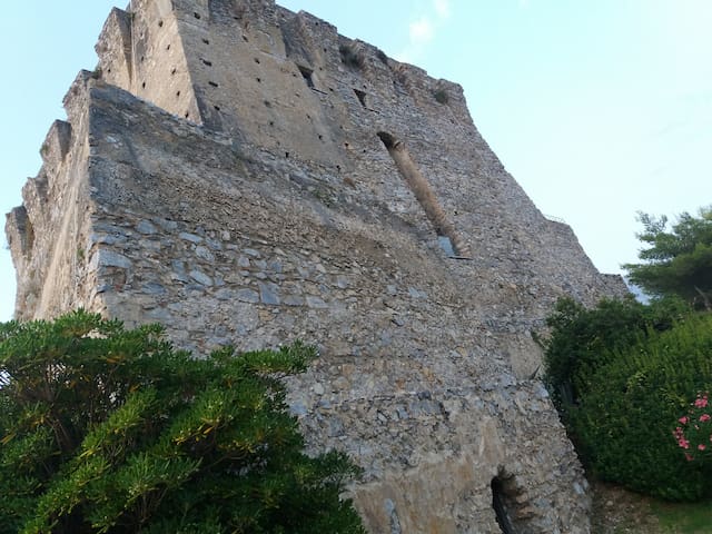
The tower is one of the most interesting watchtowers built on the Southern Italian territory during the Spanish domination, around the XVIth century, to defend the coasts from the attacks by pirates and privateers. The tower is better known as Crawford Tower, grom the name of the American writer Francis Marion Crawford (1854-1909), who lived in the tower in the first years of XXth century.
Very interesting elements of his construction are the stairways that lead to the first and second floor of the tower. The stone blocks of about 50 cm. long and 20 cm. wide are supported by two large overlapping arches. The first arch leads to the first floor, while the second one leads to the second floor. At the top of the tower a huge terrace was used to communicate and warn the other watchtowers about any incursion, through bonfires, smoke or light signals. Today, the tower is part of the architectural and cultural Calabrian heritage.
To visit the Crawford Tower please contact the Municipality of San Nicola Arcella.
Torre Crawford
The tower is one of the most interesting watchtowers built on the Southern Italian territory during the Spanish domination, around the XVIth century, to defend the coasts from the attacks by pirates and privateers. The tower is better known as Crawford Tower, grom the name of the American writer Francis Marion Crawford (1854-1909), who lived in the tower in the first years of XXth century.
Very interesting elements of his construction are the stairways that lead to the first and second floor of the tower. The stone blocks of about 50 cm. long and 20 cm. wide are supported by two large overlapping arches. The first arch leads to the first floor, while the second one leads to the second floor. At the top of the tower a huge terrace was used to communicate and warn the other watchtowers about any incursion, through bonfires, smoke or light signals. Today, the tower is part of the architectural and cultural Calabrian heritage.
To visit the Crawford Tower please contact the Municipality of San Nicola Arcella.
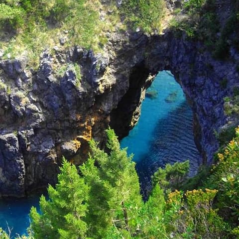
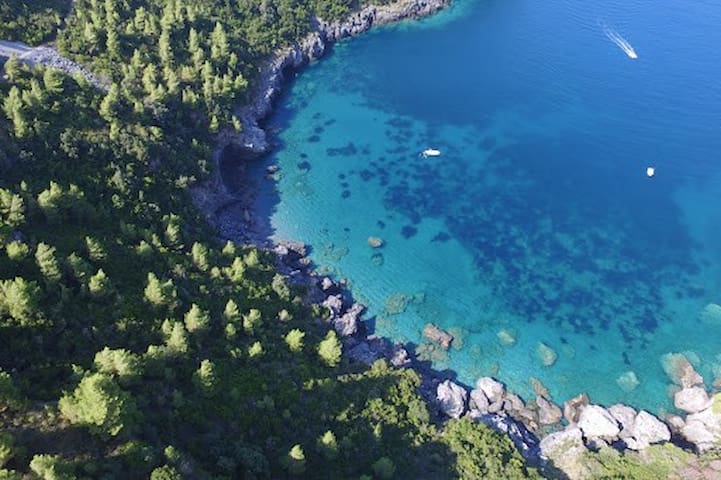
The "Spiaggia dell'Arco Magno" ("Arcomagno Beach"), is a very interesting and particular place alongside the coast, shaped by the erosive activity of the sea on the rocks,. It owes its name to the huge stone arch that delimits the access to the sea, in which there's a little sandy bay. It is a true natural location into an incredible rock structure surrounded by an unforgettable panorama.
Right next to the inlet there is the "Grotta del Saraceno", a natural cavity with a source of fresh water inside.
The place is absolutley breathtaking, of sure one of the most suggestive beach in the world.
The best way to reach it is by following a path carved into the rock, along the promenade, to see the spectacular landscape on Policastro Gulf, which includes the Dino's Island.
23 명의 현지인이 추천하는 곳
아르코 마뇨 해변
SP1The "Spiaggia dell'Arco Magno" ("Arcomagno Beach"), is a very interesting and particular place alongside the coast, shaped by the erosive activity of the sea on the rocks,. It owes its name to the huge stone arch that delimits the access to the sea, in which there's a little sandy bay. It is a true natural location into an incredible rock structure surrounded by an unforgettable panorama.
Right next to the inlet there is the "Grotta del Saraceno", a natural cavity with a source of fresh water inside.
The place is absolutley breathtaking, of sure one of the most suggestive beach in the world.
The best way to reach it is by following a path carved into the rock, along the promenade, to see the spectacular landscape on Policastro Gulf, which includes the Dino's Island.
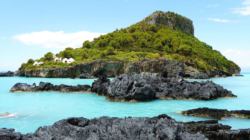
Dino's Island is the largest island situated in the Calabrian Tyrrhenian Sea. It owes its name either from Latin "aedina", a temple, or Greek "Dino", that's a vortex or storm.
Dino's island covers an area of 50 hectares (120 acres) and has a maximum altitude of 100 metres (330 ft). The north of the island is dominated by steep limestone cliffs over 80 metres (260 ft) high. Sea erosion created many amazing caves; the largest is the well known "Grotta Azzura" (the Blue Grotto), while the "Grotta Gargiulo" is almost completely submerged and reaches to 18 metres (59 ft) below sea level, a real paradise for scuba divers and underwater nature lovers! Dino's island is about 3 km far from the house.
26 명의 현지인이 추천하는 곳
Island Dino
Dino's Island is the largest island situated in the Calabrian Tyrrhenian Sea. It owes its name either from Latin "aedina", a temple, or Greek "Dino", that's a vortex or storm.
Dino's island covers an area of 50 hectares (120 acres) and has a maximum altitude of 100 metres (330 ft). The north of the island is dominated by steep limestone cliffs over 80 metres (260 ft) high. Sea erosion created many amazing caves; the largest is the well known "Grotta Azzura" (the Blue Grotto), while the "Grotta Gargiulo" is almost completely submerged and reaches to 18 metres (59 ft) below sea level, a real paradise for scuba divers and underwater nature lovers! Dino's island is about 3 km far from the house.
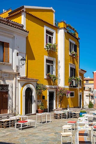
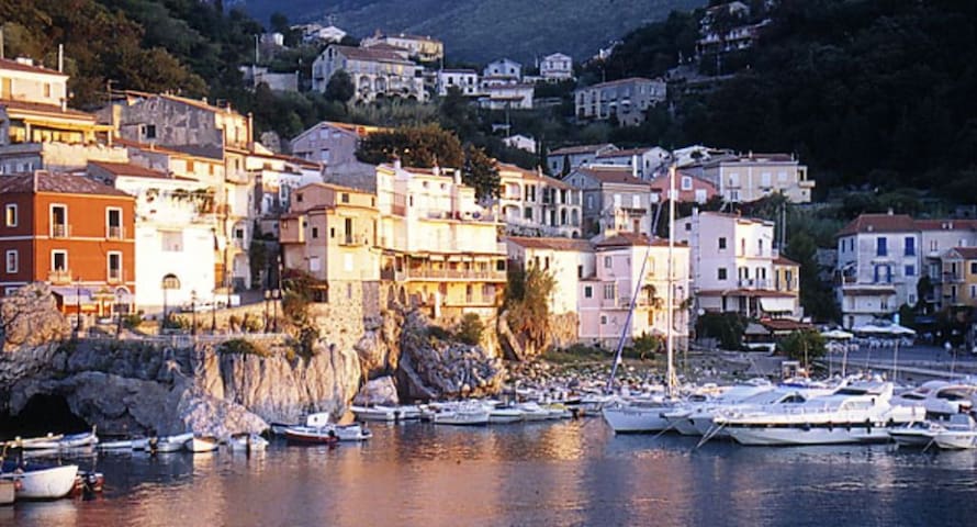
San Nicola Arcella is a small village on the coast of Calabrian Thyrrenian Sea. It draws its origins from the ancient "Lavinium", a town located in Roman times in the area of the actual municipality of Scalea.
The village has a great charm and beauty, and it certainly worths a visit. Currently, the historic center is home to small craft and gastronomic activities.
The village is located about 4 km from the house.
27 명의 현지인이 추천하는 곳
San Nicola Arcella
San Nicola Arcella is a small village on the coast of Calabrian Thyrrenian Sea. It draws its origins from the ancient "Lavinium", a town located in Roman times in the area of the actual municipality of Scalea.
The village has a great charm and beauty, and it certainly worths a visit. Currently, the historic center is home to small craft and gastronomic activities.
The village is located about 4 km from the house.
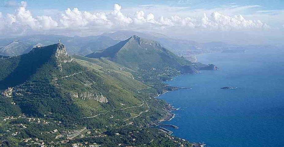
Maratea is a small town in Basilicata region, the only village of this region on the Tyrrhenian Sea. It has approximately 32 kilometres of rocky coastline, with more than twenty beaches. One of the main characteristics of Maratea is the variety of its landscapes, varying from breathtaking sea views to wooded hillsides and majestic mountains which sweep down to the sea creating steep cliffs.
The old centre of the village is situated on the northern slopes of Mount San Biagio, place of the famous Statue of Christ the Redeemer, a huge monument 21 meters high that dominates the bay.
Maratea has a small harbour, which can accommodate up to 200 boats.
It is about 25 km far from San Nicola Arcella
83 명의 현지인이 추천하는 곳
Maratea
Maratea is a small town in Basilicata region, the only village of this region on the Tyrrhenian Sea. It has approximately 32 kilometres of rocky coastline, with more than twenty beaches. One of the main characteristics of Maratea is the variety of its landscapes, varying from breathtaking sea views to wooded hillsides and majestic mountains which sweep down to the sea creating steep cliffs.
The old centre of the village is situated on the northern slopes of Mount San Biagio, place of the famous Statue of Christ the Redeemer, a huge monument 21 meters high that dominates the bay.
Maratea has a small harbour, which can accommodate up to 200 boats.
It is about 25 km far from San Nicola Arcella
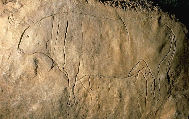
The "Grotta del Romito" (Romito Grotto) is a natural limestone cave in the Lao Valley of Pollino National Park, near the town of Papasidero, Calabria. Stratigraphic record of the first excavation confirmed prolonged paleo-human occupation during the Upper Paleolithic since 17,000 years ago and the Neolithic since 6,400 years ago. A single, but exquisite piece of Upper Paleolithic parietal rock engraving was documented. Several burial sites of varying age were initially discovered. Irregularly recurring sessions have led to additional finds, which suggests future excavation work. Notable is the amount of accumulated data that has revealed deeper understanding of prehistoric daily life, the remarkable quality of the rock carvings and the burial named Romito 2, who exhibits features of pathological skeletal conditions (dwarfism).
The town of Papasidero, place of the Grotto, is about 22 km far from San Nicola Arcella
14 명의 현지인이 추천하는 곳
로미토 동굴
The "Grotta del Romito" (Romito Grotto) is a natural limestone cave in the Lao Valley of Pollino National Park, near the town of Papasidero, Calabria. Stratigraphic record of the first excavation confirmed prolonged paleo-human occupation during the Upper Paleolithic since 17,000 years ago and the Neolithic since 6,400 years ago. A single, but exquisite piece of Upper Paleolithic parietal rock engraving was documented. Several burial sites of varying age were initially discovered. Irregularly recurring sessions have led to additional finds, which suggests future excavation work. Notable is the amount of accumulated data that has revealed deeper understanding of prehistoric daily life, the remarkable quality of the rock carvings and the burial named Romito 2, who exhibits features of pathological skeletal conditions (dwarfism).
The town of Papasidero, place of the Grotto, is about 22 km far from San Nicola Arcella
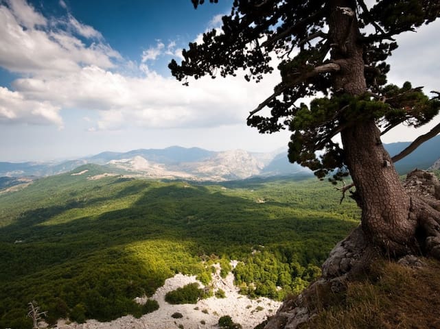
The "Parco Nazionale del Pollino" (Pollino National Park) is the largest protected area which has been recently established in Italy. It involves the Southern Apennines in Calabria and Lucania. It stretches out from the Tyrrhenian Sea to the Ionian Sea, from Cozzo del Pellegrino to Serra Dolcedorme, from Piani di Campolongo, Novacco and Lanzo, to Piani del Pollino, from the rivers Argentino and Abatemarco, to the ravines of Lao and Raganello, to the streams Peschiera and Frido. The territory, large and unpolluted, preserves rare and exceptional endemic species, like the Bosnian Pine (Pino Loricato), the Golden Eagle and the Roe Deer. The natural places, covered with large beech tree woods, snow, formed by dolomitic rocks, morainic deposits, glacial cirques, scattered with gorges and caves, are enriched with paleontological sites, like Grotta del Romito and Valle del Mercure, and archaeological sites dating back to the Greek colonization, with Sanctuaries, Monasteries, Castles, Historical Town Centers like Laino Castello, environments characterized by rural life, popular feasts, ethnic-linguistic minorities of Albanian origin of the 15th-16th century.
The whole Park area includes Pollino and Orsomarso massif. It is a mountain chain belonging to the Southern Apennines, at the border between the regions of Basilicata and Calabria, in the heart of the Mediterranean area. Its mountains represent the highest peaks of Southern Italy, covered with snow most of the year, from November to May. From its summits, over 2,200 meters of altitude above sea-level, you can see westwards the Tyrrhenian coasts of Maratea, Praia a Mare, and Belvedere Marittimo, and eastwards the Ionian coast from Sibari to Metaponto.
The nature and culture of Pollino, the global frame of its physical and human heritage, which is manifold and complex, wide and differentiated, go from naturalistic, geomorphological, vegetational, botanic, and faunistic values to a unique landscape and historical, archaeological, ethnic, anthropological, cultural, and scientific values.
The most "prestigious" and famous area is made of Dolomitic rocks, calcareous ramparts, fault walls of tectonic origins, precipices, very deep gorges, karst caves, the so-called "timpe" or gorges of volcanic origin, swallow holes, plateaus, meadows, high altitude pastures, morainic deposits, glacial cirques, erratic boulders.
The park is about 50 Km far from San Nicola Arcella.
146 명의 현지인이 추천하는 곳
폴리노 국립공원
The "Parco Nazionale del Pollino" (Pollino National Park) is the largest protected area which has been recently established in Italy. It involves the Southern Apennines in Calabria and Lucania. It stretches out from the Tyrrhenian Sea to the Ionian Sea, from Cozzo del Pellegrino to Serra Dolcedorme, from Piani di Campolongo, Novacco and Lanzo, to Piani del Pollino, from the rivers Argentino and Abatemarco, to the ravines of Lao and Raganello, to the streams Peschiera and Frido. The territory, large and unpolluted, preserves rare and exceptional endemic species, like the Bosnian Pine (Pino Loricato), the Golden Eagle and the Roe Deer. The natural places, covered with large beech tree woods, snow, formed by dolomitic rocks, morainic deposits, glacial cirques, scattered with gorges and caves, are enriched with paleontological sites, like Grotta del Romito and Valle del Mercure, and archaeological sites dating back to the Greek colonization, with Sanctuaries, Monasteries, Castles, Historical Town Centers like Laino Castello, environments characterized by rural life, popular feasts, ethnic-linguistic minorities of Albanian origin of the 15th-16th century.
The whole Park area includes Pollino and Orsomarso massif. It is a mountain chain belonging to the Southern Apennines, at the border between the regions of Basilicata and Calabria, in the heart of the Mediterranean area. Its mountains represent the highest peaks of Southern Italy, covered with snow most of the year, from November to May. From its summits, over 2,200 meters of altitude above sea-level, you can see westwards the Tyrrhenian coasts of Maratea, Praia a Mare, and Belvedere Marittimo, and eastwards the Ionian coast from Sibari to Metaponto.
The nature and culture of Pollino, the global frame of its physical and human heritage, which is manifold and complex, wide and differentiated, go from naturalistic, geomorphological, vegetational, botanic, and faunistic values to a unique landscape and historical, archaeological, ethnic, anthropological, cultural, and scientific values.
The most "prestigious" and famous area is made of Dolomitic rocks, calcareous ramparts, fault walls of tectonic origins, precipices, very deep gorges, karst caves, the so-called "timpe" or gorges of volcanic origin, swallow holes, plateaus, meadows, high altitude pastures, morainic deposits, glacial cirques, erratic boulders.
The park is about 50 Km far from San Nicola Arcella.
http://www.prolocodiamante.it/andar-per-musei/museo-del-cedro-santa-maria
The village of Santa Maria del Cedro is about 15 Km faar from San Nicola Arcella
9 명의 현지인이 추천하는 곳
Museo del Cedro
52 Via Impresehttp://www.prolocodiamante.it/andar-per-musei/museo-del-cedro-santa-maria
The village of Santa Maria del Cedro is about 15 Km faar from San Nicola Arcella
http://www.turiscalabria.it/website/?lang=en&categoria=/what/art-and-culture/castles-and-towers/&view_type=s&id=115&title=the-mural-and-chilli-pepper-town.html
Diamante is about 22 Km far from San Nicola Arcella
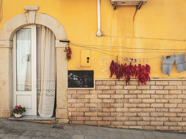
Murales Holiday Home
http://www.turiscalabria.it/website/?lang=en&categoria=/what/art-and-culture/castles-and-towers/&view_type=s&id=115&title=the-mural-and-chilli-pepper-town.html
Diamante is about 22 Km far from San Nicola Arcella
Cirella, known in the past as Cerillae, was an important port at the time of Magna Graecia and Rome and there is plenty of archaeological evidence of this in the area.
Cirella was known and visited by the Greeks and then the Romans, and also preserves the remains of the mediaeval-origin town, whose old quarter was destroyed by the Napoleonic fleet in 1806.
These ruins stand out at the top of a promontory that dominates the sea and the Island of Cirella opposite, where the watch tower to warn of Saracen raids can still be seen at its centre.
The ‘ruins’ are the remains of the old town of Cirella destroyed by the Napoleonic fleet early in the 19th century. Abandoned and neglected, whole colonnades of Greek and Roman temples were totally ransacked and many frescoes cancelled by bad weather. One of the surviving fragments portrays ‘The Madonna of the Angels’, by an anonymous painter of the late 16th century. This was detached from the crumbling wall at the end of the 1970s and has been patiently restored by the Superintendency. It is now displayed in the parish church.
The monastery dedicated to San Francesco, built in 1545, and the modern ‘Teatro dei Ruderi’, where leading theatrical pieces, concerts and various shows are produced every summer, are a short distance from the area of the ruins. In August, the theatre also hosts ‘Cirella antica festival’, which covers almost all the summer period.
There are many tourists on the Riviera dei Cedri and so, despite seating about 2,000 people, this is often insufficient.
(from http://www.turiscalabria.it)
"Ruderi di cirella" are about 20 km far from the house.
13 명의 현지인이 추천하는 곳
Ruins of Cirella
Cirella, known in the past as Cerillae, was an important port at the time of Magna Graecia and Rome and there is plenty of archaeological evidence of this in the area.
Cirella was known and visited by the Greeks and then the Romans, and also preserves the remains of the mediaeval-origin town, whose old quarter was destroyed by the Napoleonic fleet in 1806.
These ruins stand out at the top of a promontory that dominates the sea and the Island of Cirella opposite, where the watch tower to warn of Saracen raids can still be seen at its centre.
The ‘ruins’ are the remains of the old town of Cirella destroyed by the Napoleonic fleet early in the 19th century. Abandoned and neglected, whole colonnades of Greek and Roman temples were totally ransacked and many frescoes cancelled by bad weather. One of the surviving fragments portrays ‘The Madonna of the Angels’, by an anonymous painter of the late 16th century. This was detached from the crumbling wall at the end of the 1970s and has been patiently restored by the Superintendency. It is now displayed in the parish church.
The monastery dedicated to San Francesco, built in 1545, and the modern ‘Teatro dei Ruderi’, where leading theatrical pieces, concerts and various shows are produced every summer, are a short distance from the area of the ruins. In August, the theatre also hosts ‘Cirella antica festival’, which covers almost all the summer period.
There are many tourists on the Riviera dei Cedri and so, despite seating about 2,000 people, this is often insufficient.
(from http://www.turiscalabria.it)
"Ruderi di cirella" are about 20 km far from the house.
The "Castello del Principe" was originally built by the Normans on what is the highest hill by the coast, around the year 1000. The castle was restored and enriched during the Spanish domination to assume the shape and architecture currently visible.
The "Castello of Belvedere Marittimo"is about 30 km far from the house.
Castello Belvedere Marittimo
Piazza Castel RugieroThe "Castello del Principe" was originally built by the Normans on what is the highest hill by the coast, around the year 1000. The castle was restored and enriched during the Spanish domination to assume the shape and architecture currently visible.
The "Castello of Belvedere Marittimo"is about 30 km far from the house.
Sila National Park was established in 1997 and covers about 74,000 ha in Calabria. Its highest mountains are Mt. Botte Donato (1,928m), in Sila Grande, and Mt. Gariglione (1,764m) in Sila Piccola. The park is set with the Regional Decree 14.11.2002 from the Official Journal num. 63 - 17/03/2003 and includes its own Management Agency founded. This park area includes the territories formerly as part of the “Historical” Calabria National Park (1968), which protects areas of great environmental interest in Sila Piccola, Sila Grande and Sila Greca, for a total of 73.695 hectares, in 21 municipalities, 6 Mountains Communities (Comunità Montane) and 3 provinces of Calabria Region.
The "Parco Nazionale della Sila" is about 180 km far from the house.
139 명의 현지인이 추천하는 곳
실라 국립공원
Sila National Park was established in 1997 and covers about 74,000 ha in Calabria. Its highest mountains are Mt. Botte Donato (1,928m), in Sila Grande, and Mt. Gariglione (1,764m) in Sila Piccola. The park is set with the Regional Decree 14.11.2002 from the Official Journal num. 63 - 17/03/2003 and includes its own Management Agency founded. This park area includes the territories formerly as part of the “Historical” Calabria National Park (1968), which protects areas of great environmental interest in Sila Piccola, Sila Grande and Sila Greca, for a total of 73.695 hectares, in 21 municipalities, 6 Mountains Communities (Comunità Montane) and 3 provinces of Calabria Region.
The "Parco Nazionale della Sila" is about 180 km far from the house.
Fiumefreddo Bruzio (Calabrian: Jiumifriddu) is a town in the province of Cosenza. In 2005, Fiumefreddo Bruzio was awarded as one of the Borghi più belli d'italia (lit. one of the most beautiful villages in Italy).
Fiumefreddo Bruzio is about 80 k far from the house.
18 명의 현지인이 추천하는 곳
fiumefreddo bruzio
Fiumefreddo Bruzio (Calabrian: Jiumifriddu) is a town in the province of Cosenza. In 2005, Fiumefreddo Bruzio was awarded as one of the Borghi più belli d'italia (lit. one of the most beautiful villages in Italy).
Fiumefreddo Bruzio is about 80 k far from the house.
The village of Altomonte, rich in rivers and hilly landscapes, is located in Calabria. There are abundant olive groves and native vineyards producing the balbini wines, already decanced by Pliny the Elder. The village was first called Brahall, then Bragalla, Antifluvius until 1343 and finally Altomonte, when the county passed to the Sangineto and then to Sanseverino, the principals of Bisignano bound to the Ruffo of Calabria. The story has left important signs to be discovered in an itinerary that goes from the modern open air theater (now home to many international events), to medieval alleys, to the church of Santa Maria della Consolazione, a rare example of Gothic-Angolan art, and the Civic Museum, located in the former Convent of the Dominicans. With the Monastic Complex and the presence of Dominicans, wanted by Countess Cobella Ruffo in the 15th century, the town became a center of culture; hosted the philosopher Thomas Campanella, who here thought of the "City of the Sun", and novelist Matteo Bandello. A few steps from the convent, we find the Norman Castle (11th century) and the Pallotta Tower (XIth century), a square-based fortress now home to the Azzinari Museum. Finally, you reach the church of St. James the Apostle, of probable Byzantine origin. In the lower part of the village, we find the Monastery Complex of San Francesco di Paola (circa 1635), which now houses the Municipal Headquarters, considered one of the most beautiful municipi of Italy.
Altomonte, with over 300 ceremonies a year, is defined as the hamlet of weddings, as weddings from all over Italy and abroad decide to celebrate here the happy event for the beauty of these places. Among the streets and alleys of the village you can find typical products and local craftsmanship: from wine to craft products in clay, wood, wicker etc. Remarkable are the curious wooden postcards, the old embroidery, the refined liqueurs, sweets and typical products, including the Bread of Altomonte, for which the village has become a symbol of typical Calabrian cuisine.
(from https://www.e-borghi.com/en/village/Cosenza/285/altomonte)
Altomonte is about 120 km far from the house.
Altomonte
The village of Altomonte, rich in rivers and hilly landscapes, is located in Calabria. There are abundant olive groves and native vineyards producing the balbini wines, already decanced by Pliny the Elder. The village was first called Brahall, then Bragalla, Antifluvius until 1343 and finally Altomonte, when the county passed to the Sangineto and then to Sanseverino, the principals of Bisignano bound to the Ruffo of Calabria. The story has left important signs to be discovered in an itinerary that goes from the modern open air theater (now home to many international events), to medieval alleys, to the church of Santa Maria della Consolazione, a rare example of Gothic-Angolan art, and the Civic Museum, located in the former Convent of the Dominicans. With the Monastic Complex and the presence of Dominicans, wanted by Countess Cobella Ruffo in the 15th century, the town became a center of culture; hosted the philosopher Thomas Campanella, who here thought of the "City of the Sun", and novelist Matteo Bandello. A few steps from the convent, we find the Norman Castle (11th century) and the Pallotta Tower (XIth century), a square-based fortress now home to the Azzinari Museum. Finally, you reach the church of St. James the Apostle, of probable Byzantine origin. In the lower part of the village, we find the Monastery Complex of San Francesco di Paola (circa 1635), which now houses the Municipal Headquarters, considered one of the most beautiful municipi of Italy.
Altomonte, with over 300 ceremonies a year, is defined as the hamlet of weddings, as weddings from all over Italy and abroad decide to celebrate here the happy event for the beauty of these places. Among the streets and alleys of the village you can find typical products and local craftsmanship: from wine to craft products in clay, wood, wicker etc. Remarkable are the curious wooden postcards, the old embroidery, the refined liqueurs, sweets and typical products, including the Bread of Altomonte, for which the village has become a symbol of typical Calabrian cuisine.
(from https://www.e-borghi.com/en/village/Cosenza/285/altomonte)
Altomonte is about 120 km far from the house.
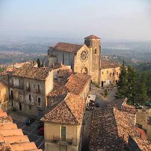
Morano is an ancient town whose name appeared for the first time on a milestone from the second century BC found in Polla in the Vallo di Diano. The engraving on the rock suggests that, at that time, the town was a pit stop along the ancient Regio-Capuam consular road.
Consisting of three districts surrounding the castle and the most important churches, the town of Morano extends towards the valley within a system of walls. Its dense and intricate urban layout has made Morano one of Calabria’s best preserved medieval historic centres.
(from http://www.turiscalabria.it)
Morano Calabro is about 85 km far from the house
7 명의 현지인이 추천하는 곳
Morano Calabro
Morano is an ancient town whose name appeared for the first time on a milestone from the second century BC found in Polla in the Vallo di Diano. The engraving on the rock suggests that, at that time, the town was a pit stop along the ancient Regio-Capuam consular road.
Consisting of three districts surrounding the castle and the most important churches, the town of Morano extends towards the valley within a system of walls. Its dense and intricate urban layout has made Morano one of Calabria’s best preserved medieval historic centres.
(from http://www.turiscalabria.it)
Morano Calabro is about 85 km far from the house
Maratea's yacht harbor is 10 minutes by road from the Centro Storico. Although a small number of fishing boats still operate from the port, most vessels are cabin cruisers and other pleasure boats owned by summer residents and visitors.
(from https://europeforvisitors.com/europe/articles/maratea-port.htm)
"Porto di Maratea" is about 24 km far from the house
17 명의 현지인이 추천하는 곳
Porto di Maratea
Maratea's yacht harbor is 10 minutes by road from the Centro Storico. Although a small number of fishing boats still operate from the port, most vessels are cabin cruisers and other pleasure boats owned by summer residents and visitors.
(from https://europeforvisitors.com/europe/articles/maratea-port.htm)
"Porto di Maratea" is about 24 km far from the house
At the extreme south of the coast of Maratea, on the border with Calabria, the territory of Castrocucco is, to some historians, the site of the ancient Greek city of Blanda from which would originate the current Maratea.
Castrocucco is characterized by the presence of three important points of interest include La Secca, the Gnola beach, the Castrocucco Castle. Just the crumbling remains of the castle belonging to the Barons Labanca and the palace "annex" directly on the beach in La Secca, are witness to the only feud on the territory of Maratea.
(from https://www.airbnb.it/manage-guidebook/2304520)
Castrocucco di Maratea is about 16 km far from the house.
Castrocucco di Maratea
At the extreme south of the coast of Maratea, on the border with Calabria, the territory of Castrocucco is, to some historians, the site of the ancient Greek city of Blanda from which would originate the current Maratea.
Castrocucco is characterized by the presence of three important points of interest include La Secca, the Gnola beach, the Castrocucco Castle. Just the crumbling remains of the castle belonging to the Barons Labanca and the palace "annex" directly on the beach in La Secca, are witness to the only feud on the territory of Maratea.
(from https://www.airbnb.it/manage-guidebook/2304520)
Castrocucco di Maratea is about 16 km far from the house.
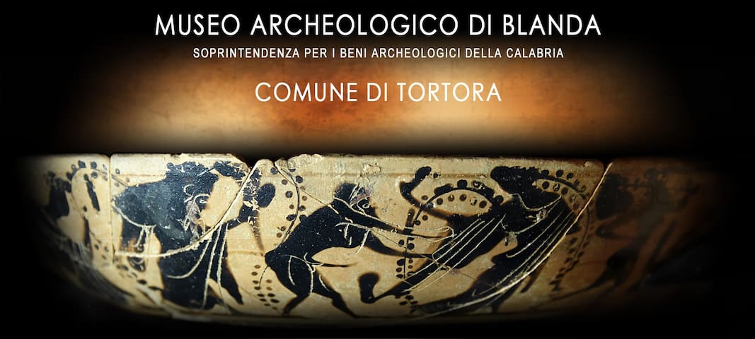
Important archaeological excavations have affected over the years the territory of Tortora and Praia a Mare, just beyond the municipal boundaries of Maratea across the river Noce, with many found objects that have allowed the creation of the museum of Blanda.
The many objects discovered have allowed the creation of the Museum of Blanda and the setting up of the exhibition " Frammenti del passato" [Fragments of the past].
The halls of the Museum are divided into four major areas that tell and revive the civilizations present in the area and there are represented: Prehistory, Enotri, Lucani and finally Romans.
In addition to the finds of the various epochs, there are effective teaching panels and interesting reconstructions of environments that make the visit, far from boring and doascal, a pleasant and educational experience.
To make the viewing experience more engaging and fun, various multimedia applications are available, including 3D TV for virtual and three-dimensional reconstruction of objects and settings, as well as tablets to interact with the exhibition path.
(from https://www.maratea.info/blanda-museum-tortora.html)
"Museo di Blanda" is about 16 km far from the house, in the centre of the town of Tortora.
http://museodiblanda.it/il-museo/
Tel. (+39) 0985 75171
Museo di Blanda
257 Corso GaribaldiImportant archaeological excavations have affected over the years the territory of Tortora and Praia a Mare, just beyond the municipal boundaries of Maratea across the river Noce, with many found objects that have allowed the creation of the museum of Blanda.
The many objects discovered have allowed the creation of the Museum of Blanda and the setting up of the exhibition " Frammenti del passato" [Fragments of the past].
The halls of the Museum are divided into four major areas that tell and revive the civilizations present in the area and there are represented: Prehistory, Enotri, Lucani and finally Romans.
In addition to the finds of the various epochs, there are effective teaching panels and interesting reconstructions of environments that make the visit, far from boring and doascal, a pleasant and educational experience.
To make the viewing experience more engaging and fun, various multimedia applications are available, including 3D TV for virtual and three-dimensional reconstruction of objects and settings, as well as tablets to interact with the exhibition path.
(from https://www.maratea.info/blanda-museum-tortora.html)
"Museo di Blanda" is about 16 km far from the house, in the centre of the town of Tortora.
http://museodiblanda.it/il-museo/
Tel. (+39) 0985 75171