
Guidebook (Work In Progress)
Hiking and sightseeing!
Nice hiking and sightseeing!
Nice hike that is pretty during most seasons with a fun (scary?) tower at the top of the hike that after going up the steps you are greeted with a view over the area. If you look closely in the right direction you may even see the farm across from us!
The route is about 6km and walking around wil take 3-4 hours. The route is marked.
To get there follow map (google) to "svens altare parking"
link to more information from Orust:
https://www.orust.se/amnesomrade/upplevaochgora/idrottmotionochfriluftsliv/vandringsleder/svensaltarestorehamn.4.ff67aea13f999476c2ac3.html
Svens Altare - Parking/Hike start
LerklevenNice hike that is pretty during most seasons with a fun (scary?) tower at the top of the hike that after going up the steps you are greeted with a view over the area. If you look closely in the right direction you may even see the farm across from us!
The route is about 6km and walking around wil take 3-4 hours. The route is marked.
To get there follow map (google) to "svens altare parking"
link to more information from Orust:
https://www.orust.se/amnesomrade/upplevaochgora/idrottmotionochfriluftsliv/vandringsleder/svensaltarestorehamn.4.ff67aea13f999476c2ac3.html
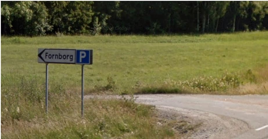
Nice hike nearby including an old fort.
You can find parking off of the road toward Hälleviksstrand (about 500m from the bus stop where you will find parking signs for "fornborg" to the left) . Park and continue walking (toward Ellös) and pass through the tunnel under road 178. Choosing left from here will lead you up a hill with a beautiful trickling stream that is full of flowers in the spring (vitsippor) and is beautiful during the rest of the year as well. Choosing right will bring you around the other way which is maybe a little more difficult to follow and we do not find as much fun.
At the precipice of the hike you will find the fort used between the stone and iron age. Not so much of the fort is left today but it is still quite fun with some informative signs, a nice view and a good place for a snack/lunch.
The main hiking route is marked and includes information along the way is about 3,5km and takes about 2 hours.
more info can be found here: https://www.orust.se/amnesomrade/upplevaochgora/idrottmotionochfriluftsliv/vandringsleder/husebyledenstorehamn.4.5214accd140df0c4d0bcc2.html
Huseby
Nice hike nearby including an old fort.
You can find parking off of the road toward Hälleviksstrand (about 500m from the bus stop where you will find parking signs for "fornborg" to the left) . Park and continue walking (toward Ellös) and pass through the tunnel under road 178. Choosing left from here will lead you up a hill with a beautiful trickling stream that is full of flowers in the spring (vitsippor) and is beautiful during the rest of the year as well. Choosing right will bring you around the other way which is maybe a little more difficult to follow and we do not find as much fun.
At the precipice of the hike you will find the fort used between the stone and iron age. Not so much of the fort is left today but it is still quite fun with some informative signs, a nice view and a good place for a snack/lunch.
The main hiking route is marked and includes information along the way is about 3,5km and takes about 2 hours.
more info can be found here: https://www.orust.se/amnesomrade/upplevaochgora/idrottmotionochfriluftsliv/vandringsleder/husebyledenstorehamn.4.5214accd140df0c4d0bcc2.html
Amazing “cave” that is fun for those that are looking for an adventure! If you want to make it through the entire circuit you will need to be small, nimble and in relatively good shape, otherwise it is anyway a nice walk in beautiful scenery! The cave has been formed by stone blocks falling and creating a pocket that stretches 25m+.
Route is not marked (only some ribbons leading to the entrance, arrow in picture showing entrance)
Park by the Torp church. Walk down the road that leads down the hill and along the cemetery to a gate into a field. Pass through the gate (close it after you!!) and follow along the right side of the field and continue along a tractor road beside an old stone fence .If you come to a barbed wire fence you have come too far.
You should look for some red ribbons in the trees between the tractor road and the cliff above. These ribbons lead the way to the opening in the blocks.
Keep moving away from the church when inside and follow along within ups and downs with some light climbing and dropping down. The church at the end a high vaulted area that delights with the last squeeze out! Exhilarating and worth the excursion! Bonus points if you can find the geocache!
Lunnebergs kyrka (grotta)
Amazing “cave” that is fun for those that are looking for an adventure! If you want to make it through the entire circuit you will need to be small, nimble and in relatively good shape, otherwise it is anyway a nice walk in beautiful scenery! The cave has been formed by stone blocks falling and creating a pocket that stretches 25m+.
Route is not marked (only some ribbons leading to the entrance, arrow in picture showing entrance)
Park by the Torp church. Walk down the road that leads down the hill and along the cemetery to a gate into a field. Pass through the gate (close it after you!!) and follow along the right side of the field and continue along a tractor road beside an old stone fence .If you come to a barbed wire fence you have come too far.
You should look for some red ribbons in the trees between the tractor road and the cliff above. These ribbons lead the way to the opening in the blocks.
Keep moving away from the church when inside and follow along within ups and downs with some light climbing and dropping down. The church at the end a high vaulted area that delights with the last squeeze out! Exhilarating and worth the excursion! Bonus points if you can find the geocache!